
Time zone EET (UTC+2) Vehicle registration EY Local time Friday 9:47 PM | Districts 3 Postal code 310 81 Website www.karya.gr Area code 26290 | |
 | ||
Weather 7°C, Wind N at 11 km/h, 96% Humidity | ||
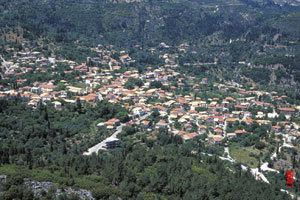
Karya (Greek: Καρυά) is a former municipality on the island of Lefkada, Ionian Islands, Greece. Since the 2011 local government reform it is part of the municipality Lefkada, of which it is a municipal unit. It lies in the central part of Lefkada. It has a land area of 30.867 km² and a population of 871 (2011 census). A large part of the population live in the former municipal seat, the town of Karyá (pop. 589).
Contents
Map of Karya 310 80, Greece
The village Karya is located on the slopes of Pyrgos at 500 m above sea level. The highest point in the municipal unit is the mountain Stavrota, elevation 1,158 m. There are four villages in the municipal unit: Karyá, Pigadisánoi (pop. 157), Egklouví (106), and Ammókampos (19).
Subdivisions
The municipal unit Karya is subdivided into the following communities (constituent villages in brackets):