
Elevation 1,241 m | Mountain range Black Forest | |
 | ||
Similar Schauinsland, Belchen, Feldberg, Kastelburg, Roßkopf (Breisgau) | ||
The Kandel is a mountain, 1,241.4 metres high, in the Black Forest in the south of Baden-Württemberg, Germany.
Contents
Map of Kandel, 79183 Waldkirch, Germany
GeographyEdit
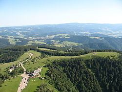
The Kandel is located 25 km northeast of Freiburg in the Breisgau and has a height of 1,241 m (4,072 ft).
The Kandel belongs to the Central Black Forest gneiss region. The overall shape of the massif was tectonically formed: the Kandel block rises table-like in a northwesterly direction from the plateau around Sankt Peter. It is surrounded by faults, some of which form clear steps in the terrain; for example the Rhine Plain lies more than 1,000 metres below the Kandel and the summits on the other side of the Elz valley are 500-600 metres lower. The ongoing uplifting of the Kandel block from the Rhine Plain (1-2 mm/year) sometimes manifests itself in earth tremors.
The Kandel massif is cut by deep radial valleys into mountain ridges, some rounded and some rocky. The steep mountainsides reach heights of 600 metres in the southwest (Glotter valley), 650 metres in the northwest (Elz valley) and a good 700 metres in the northeast (valley of the Wild Gutach). Only in the southeast does the mountain descend more gradually towards Sankt Peter by about 500 metres and to the ledge over the Zweribach waterfalls by a good 200 metres. The extensive grasslands of the southern slopes often exhibit clear thermals and are influenced by heavy thunderstorm weather patterns of the Breisgau that often arise here.
The elements of the mountain block that go back to the ice age glaciations are less obvious here that in other Black Forest mountains of comparable height.
Kandel RockEdit
The Kandel Rock (German: Kandelfelsen) is located at a height of about 1,100 m (3,609 ft) on the western slope. Although in 1981 some two thousand cubic metres of rock collapsed, it is still attractive to climbers. Its upper part is called the Devil's Pulpit, because legend has it that this is the place where witches come together to dance with the devil on Walpurgis Night (Walpurgisnacht), which is the night of 30 April/1 May. The rockfall on the Devil's Pulpit occurred on Walpurgis Night in 1981.