
Country Japan Prefecture Ibaraki Prefecture - Flower Sarcandra glabra Local time Saturday 9:30 PM | Region Kantō - Tree Podocarpaceae Population 94,281 (Sep 2015) | |
 | ||
Time zone Japan Standard Time (UTC+9) Weather 8°C, Wind SW at 11 km/h, 63% Humidity Points of interest Minato Park, Ikisu Shrine, Kaminoike Ryokuchi Park, Kamisushi Seaside Sports Park, Wadayama Ryokuchi Park | ||
Kamisu (神栖市, Kamisu-shi) is a city located in Ibaraki Prefecture, in the northern Kantō region of Japan. As of September 2015, the city had an estimated population of 94,281 and a population density of 642 persons per km². Its total area was 146.94 square kilometres (56.73 sq mi).
Contents
- Map of Kamisu Ibaraki Prefecture Japan
- Apartment in kamisu ibaraki
- Geography
- Surrounding municipalities
- History
- Economy
- Education
- Railway
- Highway
- Seaport
- Sister city relations
- Local attractions
- Notable people from Kamisu
- References
Map of Kamisu, Ibaraki Prefecture, Japan
Apartment in kamisu ibaraki
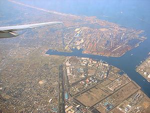
Geography
Kamisu is located in the extreme southeastern portion of Ibaraki Prefecture. The city forms a rough triangle, with Chiba Prefecture on the western side and the Pacific Ocean on the east. The Tone River flows through the city.
Surrounding municipalities
History
The village of Kamisu was established within Kashima District by the merger of the villages of Ikisu and Karuno on March 1, 1955. It was elevated to town status on January 1, 1970. The city of Kamisu was established on August 1, 2005, from the merger of the town of Kamisu and the town of Hasaki (also from Kashima District).
Economy
Kamisu has a large industrial base, with many chemical, petrochemical, specialty chemical plants, and refineries. The city is part of the Kashima Rinkai Industrial Zone. The Kashima Power Station is also located in Kamisu.
Education
Kamisu has 15 elementary schools, eight middle schools, and four high schools.