
Country Japan | Population 89,479 (1 Oct 2015) | |
 | ||
Time zone Japan Standard Time (UTC+9) Website www.city.kameoka.kyoto.jp Weather 8°C, Wind N at 6 km/h, 93% Humidity Points of interest Izumodai Jingū Shrine, Kameyama Castle, Anao‑ji Temple, Kuwayama Shrine, Kuwata Shrine | ||
Kameoka (亀岡市, Kameoka-shi) is a city in Kyoto Prefecture, Japan.
Contents
- Map of Kameoka Kyoto Prefecture Japan
- Geography
- History
- Notable people from Kameoka
- Lords of Kameoka
- Sister cities
- References
Map of Kameoka, Kyoto Prefecture, Japan
As of October 1, 2015, the city has an estimated population of 89,479, with 33,915 households and a population density of 398 persons per km². The total area is 224.80 km².
Geography
Kameoka abuts Kyoto to the east and is located to the north of Osaka. It is on the border line between former Tanba and Yamashiro providences. Together with Nantan city, the region is known as Southern Tanba, Kuchitan or Nanatan. For centuries, Kameoka served as a key transportation point to connect San'in region and Tanba providence with Kyoto. Today, the city serves as one of the fastest growing suburbs of Metro Kyoto, and Metro Osaka.
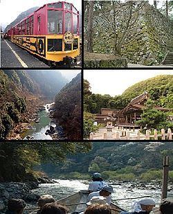
Kameoka is notable as the launch point for Hozugawa Kudari, a boat ride down the Hozu River. It is also the location of Anaoji Temple, one of the 21 temples in western Japan authorized to issue amulets in the name of the Boddhisattva Kannon.
History
Historically, the area served as a farming community for Kyoto, Japan's former capital. For centuries, area farmers provided ingredients used for traditional Japanese food served in Kyoto including chestnuts, black beans, azuki, rice, matsutake, yams, and daikon. In addition, farmers in the city provide beef, chicken and ayu (also known as sweetfish).
In the past, Kameoka was known as Kameyama and served as the provincial capital for Tanba province.