
Postcode(s) 3766 Area 3.2 km² Population 1,157 (2006) | LGA(s) Shire of Yarra Ranges Postal code 3766 | |
 | ||
Location 42 km (26 mi) from Melbourne11 km (7 mi) from Lilydale13 km (8 mi) from Belgrave | ||
Kalorama is a suburb in Melbourne, Victoria, Australia, 35 km east of Melbourne's central business district. Its local government area is the Shire of Yarra Ranges. At the 2006 Census, Kalorama had a population of 1,157.
Map of Kalorama VIC 3766, Australia
The suburb was first settled by Europeans around 1855 when Isaac Jeeves, Mathew Child and Jabez Richardson took up selections. The traditional custodians of the area are the Wurundjeri of the Kulin nation.
The Post Office opened on 1 October 1909, but was known as Hand's Corner until 1910, then Mount Dandenong North until 1926.
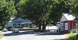
The area, renowned for its beauty, is the site of a famous lookout point named "Five Ways" which overlooks Kalorama Park, Silvan Reservoir, the National Rhododendron Gardens, and the R.J. Hamer Arboretum. Nearby attractions include William Ricketts Sanctuary, Olinda Falls, a gallery, and a range of tea-rooms, cafes and stores.
The forests of the region are dominated by various eucalypt species including mountain ash (Eucalyptus regnans), the tallest known angiosperm. The local wet sclerophyll forests form habitat for many species of native bird including the superb lyrebird (Menura novaehollandiae) which can be sometimes heard voicing its characteristic mimicry from the deeper gullies and south-eastern aspects.
The area has featured in the work of many Australian artists, including Sir Arthur Streeton.