Country Turkey Time zone EET (UTC+2) Licence plate 26 Population 3,941 (2012) Province Eskişehir Province | District Seyitgazi Postal code 26970 Elevation 1,060 m Area code 0222 | |
 | ||
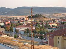
Kırka is a town in Seyitgazi district of Eskişehir Province, Turkey.
Contents
- Map of KC4B1rka KC4B1rka Mahallesi 26970 Seyitgazi2FEskiC59Fehir Province Turkey
- Geography
- History
- Economy
- References
Map of K%C4%B1rka, K%C4%B1rka Mahallesi, 26970 Seyitgazi%2FEski%C5%9Fehir Province, Turkey
Geography
Kırka is situated on the state highway in the plains of Central West Anatolia at 39°17′N 30°32′E. Çatıörem dam resorvoir is to the east of the town. The distance to Seyitgazi is 32 kilometres (20 mi) and to Eskişehir is 74 kilometres (46 mi). The population of Kırka was 3941 as of 2012.
History
There are Phrygian ruins around Kırka. But Kırka was founded in 1634 during Ottoman Empire era. Inıtially it was a temporary settlement of Turkmen nomads in the pasture. But some of these nomads decided to settle. According to tradition the founders of Kırka were forty lords, hence it was named Kırka ("forty lords" in Turkish is kırk ağa). Kırka flourished as a market center of the area. In 1972 it was declared as a seat of township.
Economy
The major town revenue is mining industry. Turkey is the major boron producer of the world and one of the most important ores is at 4 kilometres (2.5 mi) west of Kırka. After Boron products factory was opened in 1984, boron began to play a major role in town economy. Agriculture and cattle rising are among the other economic activities.
