
Elevation 212 m (696 ft) Population 2,398 (31 Dec 2008) | Time zone CET/CEST (UTC+1/+2) Local time Sunday 9:05 PM | |
 | ||
Municipal assoc. Königstein/Sächs. Schweiz Weather 12°C, Wind W at 19 km/h, 81% Humidity Points of interest Königstein Fortress, Pfaffenstein, Barbarine, Labyrinth, Miniatur‑Elbtal | ||
Sachsen festung k nigstein saxony k nigstein fortress
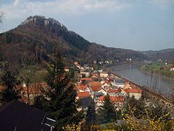
Königstein is a town in the Free State of Saxony in Germany. Königstein lies in the Sächsische Schweiz-Osterzgebirge District and has a population of 2,898 as of 2005. Near Königstein is the Festung Königstein fortress.
Contents
- Sachsen festung k nigstein saxony k nigstein fortress
- Map of KC3B6nigstein Germany
- Geography
- History
- References
Map of K%C3%B6nigstein, Germany
Geography
Königstein is located in the Elbe Sandstone Mountains. The town lies in between Pirna and the Czech border at the confluence of the Biela with the Elbe. Königstein was damaged during the flooding of the Elbe in 2002.
History
The town of Königstein was first mentioned in 1379 as a settlement near the castle of Königstein. It was named after a King of Bohemia, but eventually passed to the Saxon Margraves of Meißen. However, Königstein still retains the double-tailed lion of Bohemia in its coat of arms. During World War II the prisoner-of-war camp for Allied officers, Oflag IV-B, was located in the castle.