
Length 8,000 m | Max. length 8 kilometres (5.0 mi) | |
 | ||
Location Alta Municipality, Finnmark | ||
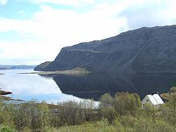
Kåfjorden (Northern Sami: Njoammelgohppi) is a fjord in Alta Municipality in Finnmark county, Norway. The 7-kilometre (4.3 mi) long fjord branches off the main Altafjorden. The village of Kåfjord and Kåfjord Church both lie along the northern coast of the fjord. The European route E06 highway follows the northern shoreline of the fjord. A new bridge over the Kåfjorden to shorten the highway E6 route around the fjord is under construction and is expected to be completed by in late 2013.
Map of K%C3%A5fjorden, 9518 Alta, Norway
The fjord was the anchorage of the German battleship Tirpitz for much of World War II, which was attacked by British midget submarines during Operation Source in 1943 and by aircraft during Operation Tungsten, Operation Mascot, Operation Goodwood and Operation Paravane in 1944.