
Prominence 1,596 m (5,236 ft) First ascent 1877 | Elevation 2,754 m Listing Ultra-prominent peak | |
 | ||
Similar Jôf Fuart, Kanin Mountains, Mangart, Jof di Miezegnot, Monte Santo di Lussari | ||
J f di montasio monta
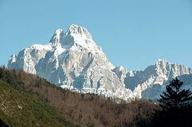
The Jôf di Montasio (Italian, Friulian: Jôf dal Montâs, Slovene: Montaž, German: Montasch) is located in the Province of Udine, in the Friuli-Venezia Giulia region of northeastern Italy.
Contents
- J f di montasio monta
- Map of JC3B4f di Montasio 33010 Province of Udine Italy
- History
- Culture
- Climbing routes
- References
Map of J%C3%B4f di Montasio, 33010 Province of Udine, Italy
With its elevation of 2,752 metres (9,029 ft), it is the second highest mountain of the Julian Alps, surpassed only by Triglav. The Julian Alps are part of the Southern Limestone Alps System.
History
Since medieval times, the steep rocks of the Montasio massif, stretching about 20 kilometres (12 mi) in an east-west direction, formed the natural border between the Imperial Duchy of Carinthia in the north and the Venetian Domini di Terraferma in the south. In World War I the mountain crest up to the Sella Nevea pass was part of the Italian Front, where the Alpini troops refuted several attacks by the Austro-Hungarian Army.
Culture
In the valleys around the mountain, local people speak four languages - Italian, Friulian, Slovene, and German. The original German name for the mountain was Bramkofel, while the original Slovene name was Špik nad Policami or Poliški Špik. However nowadays they mostly use Montasch and Montaž, borrowed from the Friulian name.
At the top of the mountain stands a cross and a bell in memory of Riccardo Deffar.
Climbing routes
There are many climbing routes from all sides. Many of them are hard rock climbing routes and ferratas, in particular from the north-east side. The normal mountaineering route is from the south side. It passes the Rifugio Brazza, at round 1650 m above the sea level. After that you can choose either the direction towards the Pipan ladder, or towards Findenegg Couloir and Suringar bivouac which is at 2400 m above the sea level.
The Ladder is 60 meters long steel structure and you should have ferrata equipment. Some sections in the Findenegg Couloir route are a bit exposed, and you also have some simple scramble at several places above the Suringar bivouac.