
Lowest pressure 978 mb (28.88 inHg) Number of casualties 15 | Dates 31 Jan 2015 – 2 Feb 2015 | |
 | ||
Type Extratropical cyclone
Winter storm
Ice storm
[Nor'easter]]
Blizzard Formed January 29, 2015 (2015-01-29) Dissipated February 3, 2015 (2015-02-03) Maximum snowfall or ice accretion Snow – 24.1 inches (61 cm) in Lunenburg, Massachusetts
Ice – 0.32 inches (8.1 mm) in North Bergen, New Jersey Areas affected High Plains, Ohio Valley, Central United States, New England | ||
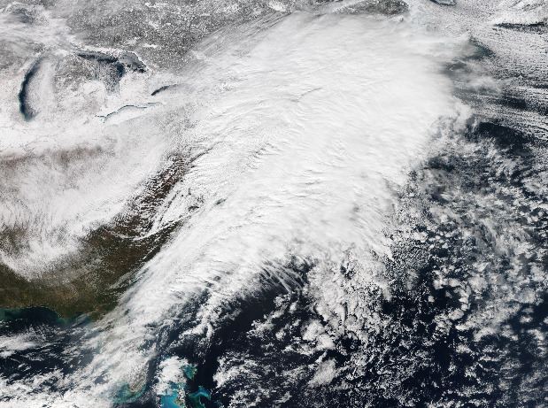
The January 31 – February 2, 2015 North American blizzard was a major winter storm that plowed through the majority of the United States, dumping as much as 2 feet (24 in) of new snowfall across a path from Iowa to New England, as well as blizzard conditions in early February of 2015. It came less than a week after another crippling blizzard which impacted the Northeast with 2–3 feet of snow. It was the first of many impactful winter storms to occur in the nation during the month of February, partly in due to an ongoing cold wave that was beginning to take shape shortly after the storm subsided.
Contents
Ahead of the storm, residents mainly in the Midwest prepared for potential whiteout or even blizzard conditions. The storm dropped as much as 19 inches (48 cm) in the city of Chicago, Illinois, making it their fifth heaviest snowstorm on record. Up to 15 people were killed by the blizzard, and knocked out power to hundreds of thousands of people.
Meteorological history
On January 30, an upper-level low moved ashore into California. Pumping some moisture from the Pacific Ocean, it began to produce snow in the high mountainous terrains of New Mexico and Arizona. It began to dive southwards into Mexico late on January 31, and at the same time, a trough had dived southwards into the United States. A surface area of low pressure developed as a result of this along an arctic front that was moving through the High Plains. Early on February 1, the winter storm began to move eastwards on a near 1,900-mile long path. Snowfall bands began to set up with rates of up to 2–3 inches (5.1–7.6 cm) per hour and strong winds, leading to blizzard conditions. The cities around the Chicago and Detroit areas were among the locations that got slammed the hardest by the blizzard. As the blizzard continued to move eastwards, winds continued to increase which resulted in higher snow drifts in some locations. The Northeast was its next target. Late on February 1, snow began to spread into parts of New York City and parts of New England. The snow continued to gradually move eastwards until it had reached the southwestern parts of New England overnight. By now the area of low pressure had reached central Pennsylvania, with its warm front passing through New York City. Because of this, snowfall totals had a sharp cutoff of about 20 miles (32 km). Instead, NYC picked up about 4 inches (10 cm) and some freezing rain. As the area of low pressure moved off the coast early on February 2, it began to rapidly intensify, with warm air being thrown into coastal front, and stronger winds which resulted in blizzard conditions, heavier snowfall totals and snowfall rates of about 2–3 inches (5.1–7.6 cm) per hour. As it continued to move to the east, the snow began to gradually taper off as snowbands pulled away, the system continued to intensify before peaking at 978 millibars (28.9 inHg) late on February 3, and dissipating a day later.
Midwest
The majority of impacts were felt in the Midwest, especially in and around the areas around Chicago On February 1, a blizzard warning was issued for the region due to the impending blizzard conditions. Several school closings were announced across most of the Midwest due to predicted snowfall accumulations of more then a foot. Chicago received up to 19.3 inches (49 cm), making it the fifth heaviest snowstorm to strike the city on record.
The same day, Springfield, Governor Rauner activated its State Incident Response Center. The Illinois Department of Transportation also announced that they would have approximately 1,700 snow trucks ready to plow snowfall on roadways and 3,700 employees on standby for help.
New England
Thousands of flights were cancelled and/or delayed due to the storm in the Northeast.
Snowfall reports
This is a list of the largest snowfall reports by state impacted by the storm. Source: