
Country Philippines Barangays ZIP code 5034 Province Iloilo | Legislative district 3rd district of Iloilo Time zone PST (UTC+8) Area 179.1 km² Local time Sunday 5:18 PM | |
 | ||
Region Western Visayas (Region VI) Weather 28°C, Wind N at 23 km/h, 64% Humidity University West Visayas State University, Janiuay | ||
Damires hills tierra verde resort brgy damires janiuay iloilo
Janiuay is a first-class municipality in the province of Iloilo, Philippines. According to the 2015 census, it has a population of 63,905 people.
Contents
- Damires hills tierra verde resort brgy damires janiuay iloilo
- Map of Janiuay Iloilo Philippines
- Geography
- Barangays
- Sto Tomas
- Danao
- Matag ub
- History
- Demographics
- Economy
- Transportation and telecommunications
- Heritage buildings
- Other landmarks
- References
Map of Janiuay, Iloilo, Philippines
The municipality is located 33 kilometres (21 mi) north-west of Iloilo City. It was created in 1769.
Geography
Two rivers coming from the north-west cuts in parallel through Janiuay. One is the Suage River and the other is the Magapa River which provide natural irrigation supporting the mainly agricultural town of Janiuay. The Suage river bridge was once witness to fierce fighting between Japanese Imperial forces and the combined Filipino and American troops including the recognized Ilonggo guerrilla fighters. The Magapa river bridge was built after World War II.
Barangays
Janiuay is politically subdivided into 60 barangays.
Sto. Tomas
Sto. Tomas approximate population is 500-800. Sto. Tomas (Pakol to locals) is bounded by Madong in the east, Mangil in the north-east and Danao in the south west. It is accessible by three class C feeder roads in the east, south-west and south-east. Agriculture centers around rice, corn, coffee, beans, sugar cane, and copra. Traces of sweet mango farms are starting to gain roots especially close by the public elementary school. General topography is flat rice fields on the east and hill-valley-hill dotted by bamboos, coffee, mango, banana, coconuts and other fruit tree crops in the remaining areas. Water source are via deepwells and rice produce is primarily dependent on rainfall.
Motorbike and tricycle are the easiest mode of transportation and also four-wheels during festive events. Ride is some 30 minutes from the town proper. Electricity is subscribed by 15-25% of the population. Wireless cellphone carrier SMART covers the area and is generally available in 20-25% of the population. English language is generally understood and spoken fairly by locals in certain situation with foreigners.
Danao-Sto. Tomas Elementary School established during the 50's is located on the highest hill of the surrounding barrangays and view of rice fields in the east is impressive especially in the morning. An old artesian well stands within the school grounds - part of an effort to secure deep water for the school in the 60's (WVA).
Danao
Pueblo Danao has a history. It was established by Fr. Eugenio Moya in 1766. It lasted for eight years until Fr. Moya was forced to move to adjacent Pueblo Yabon for fear on his life on errant moros and the locales. The moros and the locales set camp in the forest of Danao away from forced labor edict from Spanish Principalia and administered by priests of Poblacion Janiuay. The moros and the locales raised in arms against Catholic conversion and had attempted to poison and kill Fr. Moya. Pueblo Danao became a prized possession disputed by Pueblo Quipot and Principalia Masin (now Maasin) because of its rich farmland in the west bounded by the Suage river and the rumor about rich mineral deposits in the hills of Kantong (now Danao Gantong). When Pueblo Quipot was moved to Poblacion Janiuay in 1769, Pueblo Danao was downgraded to a barrio and became part of Janiuay.
Danao is divided into three mini locales (mini-barrangay), Danao I, Danao 2 and Danao Gantong. Each mini barrangay has about a population of 300- 400. Danao is bounded by Sto. Tomas (North-West), Mangil (North), Madong (East), Tambal (South-West),Calmay (West), Caraudan (West) and Aguingay (South-West).
It is accessible by two class C feeder roads from Poblacion Janiuay in the east, south-west and south-east. Agriculture centers around rice, corn, coffee, beans, sugar cane, and copra. Traces of sweet mango farms are starting to gain roots especially close by the public elementary school. General topography is flat rice fields on the east and hill-valley-hill dotted by bamboos, coffee, mango, banana, coconuts and other fruit tree crops in the remaining areas. Water source are Suage river in the south-west and via deepwells and seasonal rainfall in the east.
Four wheels are a means of transportation including motorbike and tricycle. Ride is some 30 minutes from the town proper. Electricity is subscribed by 15-25% of the population. Wireless cellphone carrier SMART covers the area and is generally available in 20-25% of the population. English language is generally understood and spoken fairly by locals in certain situation with foreigners.
Danao-Sto. Tomas Elementary School established during the 50's straddles Sto- Tomas and Danao Gantong. An old artesian well stands north of the school grounds - part of an effort to secure deep water for the school in the 60's (WVA). It is believed that the well was an exploratory bore hole to determine and analyze the mineral content of the sub-surface of the surrounding area. Bore hole samples including sediment samples from surrounding open wells (Rapo, Brasileno, Casiple) were collected and sent for analysis. No new samples are requested by the Bureau of Mines. lorenzo arillo is the longest brgy. captain of brgy. danao (1960-2003).
Matag-ub
Matag-ub was formerly Pueblo Binogsukan in 1766. Aetas set camp in these areas helping the Moros raid and fight wars with the Augustinian priests Marin, Carvajal, Gorrosari and Llorente of Poblacion Janiuay for forced labor erecting the churches and cemetery of Poblacion Janiuay.
History
In the summer of 1578, the natives of Tala-ugis trudged up from the coast to establish a settlement northward in the interior along Suage River. The first settlers were led by families of Gamuk, Hutikon, Uganet and Pagdakton, who settled themselves in what is currently known as barangays Matag-ub, Danao, Yabon and Quipot.
More than a century later, Spaniards came along these parts of Panay.
Early in 1738, Datu Buhawi of Yabon recognized the Spanish government, thus subjugating himself and his barangay to Spanish rule. But, Datu Dumagtol of nearby Ubian refused to follow suit. He led his subjects to the mountains to resist against the Spanish colonizers.
The Spanish governor Francisco Bayot de Ocampo recommended to the Principalía to transfer the seat of government, and in the following year (1770), the settlements were strengthened in their administration in what they called "Janiuay".
While there is no certainty, there are several legends of how the place got its name. One is that it came from the ruling Datu's sons named "Han" and "Oway". Another is that the words "hani" (whisper) and "oway" (rattan) were combined.
A strong typhoon followed by heavy rain in June 2008 caused the Suage river to overflow, damaging river bank communities and infrastructures. The flooding caused the river to be re-drawn and encroached the river banks by about 200 meters from its original location. Suage bridge remains structurally sound despite the flooding and encroachment.
Demographics
In the 2015 census, the population of Janiuay was 63,905 people, with a density of 360 inhabitants per square kilometre or 930 inhabitants per square mile.
Economy
Cultivation of rice, corn, sugar, copra, coffee, banana, abaca fiber, fowls (and gamefowls), goat and cattle raising are the main sources of livelihood. Commerce for these products are generally brought into the town proper for market. The rainfall generally dictate the commerce of these products as the river go dry in summer months.
Most of these are coming from the west, north-west and south-west of the town.
Transportation and telecommunications
Janiuay can be accessed from all directions with good paved concrete and asphalt road infrastructures from the east, north and south. Mode of transport can either be jeeps, motorcycles fitted with cabs for 2-5 persons locally known as tricycles for inter barrangay transport. Intertowns are plied by buses, jeeps and private vans. Within the town, "trysikad" - a bicycle fitted with a cab for 2 people are commonly available.
Communication is generally available with nationwide carriers such as PLDT, Globelines and Smart competing with local and aging analog Pantelco.
Electricity is sourced from electric cooperative Ileco II supplying 75% of the town proper and about 25% of the neighboring barangays.
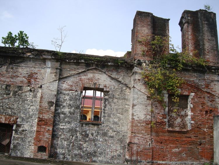
Heritage buildings
Janiuay prides itself on two heritage infrastructure dating back from 1760.
The Janiuay Catholic Church was built of sandstone, lime stone and layered bricks and was completed in February 1770. Its belfry used to carry three magnificent bells, the largest weighing close to a ton. World War II damaged the belfry, and the bells were lowered to ground after the war. The largest bell crashed down during the relocation and suffered a crack 18 inches (460 mm) in length from its lip upwards. When sounded it gives a distinct baritone rattling sound that can be heard for miles. It is now mounted in the new church's belfry built in the late 60s.
Another heritage infrastructure is the Janiuay Cemetery. It was built much later, in 1870, and is also walled with ancient sandstone and bricks brought from distant locale some 30 km away in what is now known as the town of Dingle. Spanish Fr. Llorente directed the construction of this cemetery in the Gothic design of his time. The Janiuay town cemetery is located a kilometer east of Janiuay Catholic Church.
Janiuay is also home to several heritage mini sugar mills owned by landed Spanish mestizos and Swiss descent. These mini sugar mills have seen their own time and once produces brown sugar. Wrought steel rotary crushers driven by water buffaloes or carabaos extract sugar from canes and cooked in large vat until brown and solid.