
Charter 1866 Time zone EET (UTC+2) | Local time Sunday 8:46 AM | |
 | ||
Area rank 156th largest in Finland Weather -2°C, Wind NW at 8 km/h, 87% Humidity | ||
Janakkala is a municipality of Finland. Its administrative centre is in Turenki, which is often erroneously shown on maps as being "Janakkala".
Map of 14200 Janakkala, Finland
It is located in the province of Southern Finland and is part of the Tavastia Proper region. To the south, Janakkala shares a boundary with Riihimäki, the Northern neighbour being Hämeenlinna. The municipality has a population of 16,862 (31 March 2016) and covers an area of 547.46 square kilometres (211.38 sq mi) of which 38.63 km2 (14.92 sq mi) is water. The population density is 30.8 inhabitants per square kilometre (80/sq mi). In Janakkala the rate of unemployment is 9.7% and the rate of municipal taxes is 19.5%.
Paper mill is located in Tervakoski.
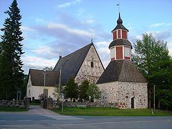
Sites of particular interest include: Hakoinen fortress hill and manor house, the latter being privately owned; St Lauri's (Lawrence's) mediaeval stone church; the Torppari Museo (authentic wooden village buildings and windmill) and numerous Bronze Age sacrifice stones, all in Janakkala village.
The place where actor Ida Aalberg was born is located in Leppäkoski village.
The municipality is unilingually Finnish.