
Area 174.5 km² Local time Saturday 1:03 PM | Population 21,157 (2005) | |
 | ||
Time zone Pacific, Mountain and Central time. Weather 29°C, Wind S at 6 km/h, 18% Humidity | ||
The municipality and town of Jamay is located in the eastern portion of Jalisco, Mexico, at coordinates 20°17.4′N 102°42.6′W, at a height of 1530 meters above sea level. The municipality extends from 20° 25' to 20° 13' N, and from 102° 38' to 102° 44' W.
Map of Jamay, Jalisco, Mexico
It covers 174.49 km², representing 0.14% of the total surface area of the state. The municipality of Jamay adjoins to the north with the municipalities of Ocotlán and La Barca; to the east with the municipality of La Barca; to the south with the municipality of La Barca, the state of Michoacán and the municipality of Ocotlán; to the west with the municipality of Ocotlán and Lake Chapala.
The municipality has 17 towns, including Jamay (the municipal seat), San Miguel de la Paz, San Agustín, Maltaraña and Los Capulines.
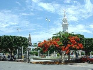
Jamay is famous for a monument located in the center of the main square in memory of Pope Pius IX. Jamay is one of the Largest growing municipalities in Jalisco. Hosting peagants every independence day in September. Holding major sporting events.