
- location Pará - elevation 40 m (131 ft) | - elevation 460 m (1,509 ft) Source Pará | |
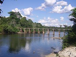 | ||
The Jamanxim River is a river of Pará state in north-central Brazil. Originating in the Serra do Cachimbo, it is a tributary of the Tapajós, into which it flows a few km upstream from Itaituba.
Map of Jamanxim River, State of Par%C3%A1, Brazil
Its hydroelectric potential, along with that of the Tapajós, was assessed by Eletronorte (Centrais Elétricas do Norte do Brasil S.A.), the regional power authority, identfying nine potential dam sites, including four along the Jamanxim. at Cachoeira dos Patos, (estimated at 28 MW); Cachoeira do Caí, (estimated at 802 MW); at Jardim do Ouro and at Jamanxim (estimated at 881 MW). If all were constructed, these dams would flood a total of 103,700 ha, including 33,216 ha of the Jamanxim National Park and 25,849 ha of the Jamanxim, Itaituba I, Itaituba II and Altamira national forests.
The river flows through the Itaituba I National Forest, a 220,639 hectares (545,210 acres) sustainable use conservation area established in 1998. The river basin also contains part of the 538,151 hectares (1,329,800 acres) Rio Novo National Park, a conservation unit created in 2006.