
- summer (DST) CEST (UTC+2) Area 57.85 km² | Elevation 315 m Local time Friday 10:26 PM | |
 | ||
Weather 4°C, Wind W at 6 km/h, 83% Humidity Points of interest Sudetes, Hochwald, Zdislavina studánka, Nový Falkenburk, Starý Falkenburk | ||
2in1 jablonn v podje t d
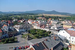
Jablonné v Podještědí (German: Gabel) is a town in Liberec District, Liberec Region, Czech Republic. It has a population of 3,775 (2006 est.).
Contents
- 2in1 jablonn v podje t d
- Map of 471 25 JablonnC3A9 v PodjeC5A1tC49BdC3AD Czechia
- Jablonn v podje t d kl ter dominik n historie
- History
- References
Map of 471 25 Jablonn%C3%A9 v Podje%C5%A1t%C4%9Bd%C3%AD, Czechia
Jablonn v podje t d kl ter dominik n historie
History
Until 1918, the town was part of the Austrian monarchy (Austria side after the compromise of 1867), head of the Gabel district (later Gabel bei Niemes), one of the 94 Bezirkshauptmannschaften in Bohemia.
References
Jablonné v Podještědí Wikipedia(Text) CC BY-SA