
Elevation 1,274 m Parent range Dinaric Alps | ||
 | ||
Similar | ||
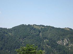
Jablanik (Serbian Cyrillic: Јабланик) is a mountain in western Serbia, near the town of Valjevo. Its highest peak Jablanik has an elevation of 1,275 meters(10001020_
Map of Jablanik, Vujinova%C4%8Da, Serbia
above sea level.
Jablanik is located at the source of the river Jablanica. It is separated from nearby Medvednik mountain by high pass Stolica, while the Debelo Brdo saddle separates it from Povlen in the southeast. The highest peak has the same name as the mountain itself - Jablanik, and is 1,275 m high. The hills around the peak are mainly forested but the peak itself is barrent, so if visibility is good the view from above is breath-taking. Grid square of the mountain is JN94TE.
References
Jablanik Wikipedia(Text) CC BY-SA