Neha Patil (Editor)

Itacoatiara, Amazonas

Updated on
Edit
Like
Comment
Share on FacebookTweet on TwitterShare on LinkedInShare on Reddit
Country
  
Brazil

State
  
Amazonas

Elevation
  
40 m (130 ft)

Area
  
8,892 km²

Team
  
Penarol Atlético Clube

Region
  
North

Founded
  
April 24, 1874

Time zone
  
BRT (UTC−4)

Local time
  
Thursday 4:37 PM

Itacoatiara, Amazonas httpsmw2googlecommwpanoramiophotosmedium

Weather
  
27°C, Wind NE at 10 km/h, 82% Humidity

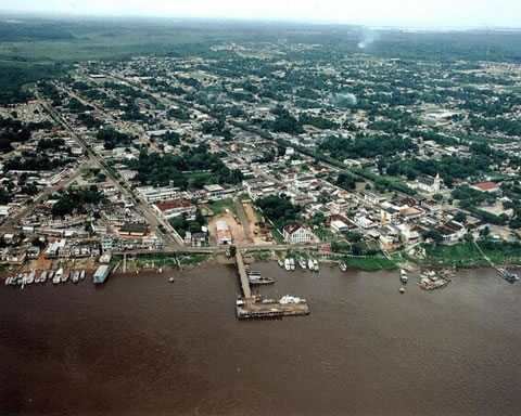
Itacoatiara is a municipality in central eastern portion of state of Amazonas, northern Brazil. It is 176 km east by air or 270 km downstream by river from Manaus. It is the third most populous town in the state, on the bank of the Amazon River. Its population was 95,714 (2014) and its area is 8,600 km². The town is known as "city of painted stone" - which is its name translated from Tupi. Itacoatiara has an important port, which is responsible for a considerable amount of cargo transportation in Amazonas.

Contents

Map of Itacoatiara - State of Amazonas, Brazil

History

  • In 1655, an aldea named Arroquis, on Albi Island on the Madeira River, was founded by Portuguese Jesuit António Vieira. It was thereafter moved four times due to aggression by the Mura indigenous people.
  • In 1757, the inhabitants of aldea Abacaxi (where did the inhabitants of Arroquis go?) moved to the left bank of the Amazon River, where Itacoatiara is now located.
  • In 1758, Francisco Xavier de Mendonça passed through the region for the second time in order to found the captaincy of São José do Rio Negro.
  • In 1759, the aldea was elevated to the category of village, and was then called Serpa. Itacoatiara became an actual town by law 74 of December 10, 1857, but in 1858 it was once more considered a village, named Nossa Senhora do Rosário de Serpa. Finally, on April 25, 1874, by law 283, Itacoatiara was again elevated to the category of town, with its current name.
  • References

    Itacoatiara, Amazonas Wikipedia