
Country Albania River mouth Adriatic Sea Source Kodër-Thumanë | Main source Kodër-Thumanë, Albania Length 79 km Mouth Adriatic Sea | |
 | ||
The Ishëm (or Ishmi) is a river in western Albania, which brings water to the area north of the Albanian capital, Tirana. It forms part of a watercourse (Tiranë-Gjole-Ishëm), but only the lower third of the watercourse is known as the Ishëm. The Ishëm proper is formed at the confluence of the rivers Gjole and Zezë, a few km northwest of Fushë-Krujë. It flows into the Adriatic Sea near the town Ishëm. The length of the watercourse is recorded in different sources as between 74 and 79 km.
The Ishëm is formed from several rivers which arise to the northeast of Tirana in the Skanderbegg mountains beyond the Krujë range. The most important of these are:
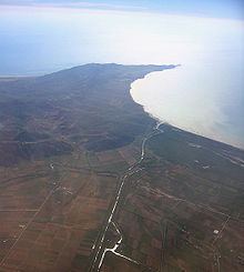
From the point where the Zeze joins the Gjole, the river is known as the Ishëm. It flows in a westerly direction until it reaches the edge of the Tirana Plain, then turns to the northwest and heads for the Adriatic. In this part of its journey it passes through a town with the same name. Shortly before the mouth of the river, it is joined by the Droja river, a stream which arises in the mountains northeast of Krujë. The Ishëm discharges into the Adriatic to the southwest of Laç in the Rodon Bay, which is bounded on the western edge by the Cape of Rodon and forms part of the Drin Gulf.
The drainage basin of the Ishëm covers a total area of 673 km2. The average discharge at the mouth of the river is 20.9 m³/s. The highest annual discharge is over six times the annual minimum.
The Ishëm and its tributaries, the Lanë and the Tiranë, are seriously polluted. Wastewater from industry and the city of Tirana empties into the rivers without being processed. The quantities of ammonia, nitrogen dioxide, and suspended solids exceed EU legal limits on several different measures. At its mouth, the river smells very bad and the bay is polluted by the wastewater, plastic, and other detritus from Tirana, which threatens an important sea turtle breeding ground.
It is possible that the Tiranë river and the Zeza were not always tributaries of the Ishëm, but used to flow into the Erzen. It has been suggested that at an earlier time they crossed the Plain of Tirana in a southwesterly direction, breaking through the chain of hills at the western edge of the plain where there are now two valleys (at Vorë and at Yzberisht), and entering the Erzen river valley. The rivers would have adopted their current, northerly course, as a result of subsidence in the Plain of Tirana.
The city of Bendensis, later called Stephaniaka, was located at the mouth of the Ishëm. It was the seat of the diocese of Benda.