
Population 1,851 (2011) Sovereign state United Kingdom Local time Wednesday 5:54 PM | OS grid reference SK436519 Post town NOTTINGHAM Dialling code 01773 | |
 | ||
Weather 13°C, Wind SW at 11 km/h, 59% Humidity | ||
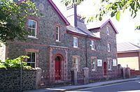
Ironville in Derbyshire, England, was built about 1830 by the Butterley Company as a "model village" to house its workers. The population of the civil parish was 1,851 at the 2011 Census. It is situated between Riddings and Codnor Park.
Map of Ironville, Nottingham, UK
John Wright and William Jessop had purchased the land adjacent to the Cromford Canal from Lancelot Rolleston of Watnall in 1809.
The village was notable for its large gardens, and its rural setting. The Mechanics Institute was built in 1846; schools were provided in 1850 and a parish church in 1852.
The local authority demolished most of the old village in the late twentieth century.
Nearby is Pye Hill and the bend in the Cromford Canal where it turns southward down the Erewash Valley and the junction with its extension to Pinxton.
About a quarter of a mile north east is another transport landmark, Pye Bridge at the junction of the Erewash Valley railway line and the extension to Ambergate. Part of the line to Ambergate is now preserved as Midland Railway - Butterley, which terminates just south of the former Pye Bridge Station.