
Built 1849 NRHP Reference # 76000732 Area 4,452 m² | Architect A. Dowling Opened 1849 Added to NRHP 29 September 1976 | |
 | ||
Similar Upper Iowa River Bridge, Waterloo Ridge Lutheran, Old East Paint Creek Lut, Allamakee County Court Ho, Effigy Mounds National | ||
Hero of robots iron post vs falcon hard
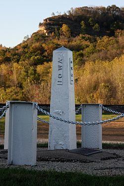
Iron Post is a historic boundary marker located in New Albin, Iowa, United States. An Act of Congress on March 3, 1849 sought to resolve the boundary issue between the State of Iowa and the newly established Minnesota Territory. This cast iron post was placed here by Captain Thomas Lee of the U.S. Army Corps of Topographical Engineers. He determined that North latitude 43 degrees, 30 minutes was indeed the border between the two entities, which the United States Congress had designated on August 4, 1846 as Iowa's northern border. It also served as a correction for the townships that had been established below the line, and as a practical surveying base for the territory to the north from this point all the way to the Big Sioux River.
The post is an obelisk that rises 54 inches (1.4 m). It is painted an aluminium color, and bears inscriptions on its four faces: "Iowa" (south), "Minnesota" (north), "1849" (east), and "Lat 43 degrees 30 minutes" (west). It was brought here across the frozen Mississippi River from Victory, Wisconsin by John Ross on a sled pulled by a team of oxen. The post was listed on the National Register of Historic Places in 1976.