
Topo map USGS Jumbo Mountain Prominence 157 m Country United States of America | Elevation 2,955 m | |
 | ||
Similar Smoky Dome, Mores Mountain, Trinity Mountain, Goat Mountain | ||
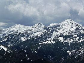
Iron Mountain, at 9,694 feet (2,955 m) high is one of the peaks of the Soldier Mountains of Idaho. Iron Mountain is located at the west end of the range northwest of Fairfield in Camas County and Sawtooth National Forest.
Map of Iron Mountain, Idaho 83327, USA
While only a class 2 ascent, the primary route up Iron Mountain is 11 miles (18 km) one way. The primary trail to the summit is open to use by two wheel motorized off-road vehicles. An old Forest Service fire lookout can be found on the summit.
The northern slopes of Iron Mountain are drained by Deadwood Creek, a tributary of the South Fork Boise River. Heart Lake is just north-northeast of Iron Mountain while Upper Deadwood Lake is southeast of the peak. Iron Mountain is northwest of Boardman Peak.
References
Iron Mountain (Idaho) Wikipedia(Text) CC BY-SA