
Existed: 1955 – 1971 To: I‑95 Constructed 1955 | From: I‑93 Length 11.7 km | |
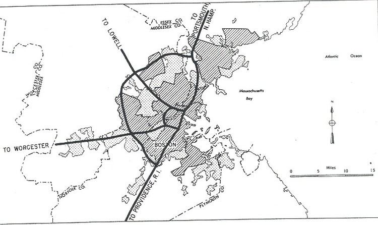 | ||
The Inner Belt in Boston was a planned six-lane, limited-access highway that would have run through parts of Boston, Brookline, Cambridge, and Somerville.
Contents
- Map of Inner Belt Rd Somerville MA 02143 USA
- Original plan
- Cancellation
- Re use of rights of way
- References
Map of Inner Belt Rd, Somerville, MA 02143, USA
Original plan
The highway would have been called Interstate 695 and would have provided a circumferential route inside the Route 128 corridor. A 1955 plan suggested this routing:
(A 1948 plan called for the Southeast and Southwest Expressway to meet the Inner Belt at the same point.)
Cancellation
The project was canceled in 1971 after intense protests organized by community activists, and following Gov. Francis Sargent's 1970 moratorium on highway construction inside Route 128. It would have displaced some 7,000 people from their homes and created what opponents at the time called a "Chinese wall" dividing long established neighborhoods, and would have gutted large parts of the city of Cambridge and the Boston neighborhood of Roxbury. There was also speculation that the construction of the Inner Belt would essentially bypass downtown Boston completely, resulting in economic stagnation in a city that was already having considerable financial problems. It was one of the first large highway projects to be blocked by local opposition. Unresolved traffic problems resulting from the cancellation were among the factors eventually leading to Boston's Big Dig highway project, decades later.
The Northwest Expressway was to carry Routes 2 and 3 along a four-lane highway from the north-west (the current outer intersection of U.S. 3 and Route 128 in Burlington) via Cambridge to connect with the Inner Belt in Union Square, Somerville. Instead, the Route 2 highway was never re-routed to the Fitchburg Line right of way, and alternately now terminates along the right of way of the old Concord Turnpike (Route 2). That intersection left the highway terminating at a traffic circle in northwest Cambridge, where it intersected Route 16. In the 1980s, the rotary was replaced by a traffic light and the highway was connected to the park-and-ride garage at the Alewife station on the newly extended Red Line.
An outer belt, Interstate 495, was eventually completed around Greater Boston.
Re-use of rights-of-way
With the cancellation of the "Southwest Corridor" route for I-95, and the resultant alternate usage of much of that right-of-way for a significant length of the relocated southwest section of the MBTA Orange Line subway's above-ground run, Route 128 between I-95 South and I-95 North was made part of the Interstate system as I-95. The right-of-way for the I-695 portion of the beltway in Roxbury had already been cleared and now contains an arterial road, Melnea Cass Boulevard. The Southwest Corridor portion of the right of way was converted into Southwest Corridor Park and the new route for the new depressed southern section of Boston's Orange Line subway, from the Tufts Medical Center subway station south-westwards. The older elevated Orange line right of way along Washington Street was subsequently torn down by 1987, and eventually replaced by the Silver Line rapid bus service.
Remnants of the Inner Belt were visible for many years on Interstate 93 at what is now the Storrow Drive Connector interchange (Exit 26 southbound) in Somerville (which would have been the northern terminus of I-695) and at the Massachusetts Avenue interchange in Boston (which would have been the Route 3/I-95 junction at the southern terminus of the beltway). Some, but not all, of these remnants have been demolished as part of the Big Dig; in particular, the Leverett Connector uses the northern pair of ramps in Somerville and had to be built around the southern pair of ramps. The southern portion which still extends beyond the cloverleaf in the Westwood/Canton area is used to store highway equipment. A spur just north of the new Zakim Bridge on I-93 North was intended to connect to the Inner Belt.
An industrial park in Somerville, built on the remnants of the B&M's Yard 8, near the intended northern terminus of the highway is built around a street known as "Inner Belt Road".