
States: Iowa
Illinois | Length 43.42 km | |
 | ||
West end: I-80 / US 6 in Davenport, Iowa East end: I-74 / I-80 near Colona, Ill. Counties: Iowa
Scott
Illinois
Rock Island
Henry | ||
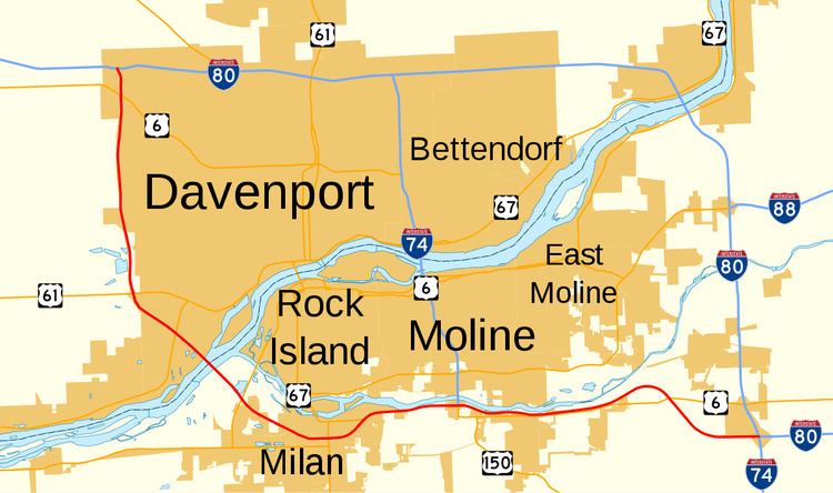
Interstate 280 (abbreviated I-280) is an auxiliary highway that makes up the western and southern portions of the beltway around the Quad Cities of Illinois and Iowa. The freeway starts at I-80 near Davenport, Iowa and ends at I-80 near Colona, Illinois; its eastern part runs concurrent with I-74 to return to I-80. I-280 forms the southern part of a circle around the Quad Cities as well as forming part of a bypass (along with I-80) for U.S. Highway 61 around Davenport. This road is 26.98 miles (43.42 km) long.
Contents
Map of I-280, United States
Route description
I-280 begins at a directional T interchange with Interstate 80 on the northwestern outskirts of Davenport. U.S. Route 6 (US 6) and US 61 join I-280 from opposite directions of I-80 at the interchange. It heads south along the western edge of Davenport. At the Kimberly Road exit, US 6 splits off to the east. It continues south for 4 miles (6.4 km), crossing Duck Creek, towards a diamond interchange with Scott County Road F65 (CR F65), which becomes Locust Street in Davenport.
Further south, I-280 passes the 620-acre (250 ha) West Lake Park. South of West Lake Park, US 61 splits away from the interstate on its way towards Muscatine. In the other direction, U.S. Route 61 Business heads towards the Davenport riverfront. South of US 61, I-280 curves to the southeast towards the Mississippi River. It drops into the river valley and meets Iowa Highway 22 (Iowa 22). It continues southeast and crosses the river via the Sergeant John F. Baker, Jr. Bridge.
In Illinois, I-280 runs for 17.60 miles (28.32 km). It runs southeast from the Baker Bridge to Milan, where it parallels the Rock River. I-280 joins with I-74 at the Quad Cities International Airport; this concurrency continues for 9.4 miles (15.1 km) before terminating at the I-74/I-80 interchange.
On the SE corner of the Quad Cities (in Illinois) I-280 heading East ends and becomes I-80 while I-80 heads South from Le Claire, Rapids City, and Port Byron. I-80 heading South becomes I-74 which (after going through the center of the Quad Cities hooks up with I-280. This exchange is called The Big X.
History
Interstate 280 has been at the center of a few debates regarding its routing. In the early 1990s, the state of Illinois suggested, via AASHTO and ISTEA hearings, swapping the I-80 and I-280 designations around the Quad Cities. The plan would have also changed I-74 to I-174. This was challenged by the state of Iowa, and the idea was dropped.
One of the reasons Illinois pursued the matter was due to the configuration of the eastern terminus of I-280; as a simple cloverleaf interchange, through I-80 traffic (along the north and east branches) was required to exit on both directions. Thru I-74 traffic (along the west and south branches) is also required to exit on both directions. I-280 runs due west from the interchange.