Country Spain Time zone CET (UTC+0) Area 38.15 km² Population 30,173 (2014) | Elevation(AMSL) 558 m (1,831 ft) Postal code 35250 Local time Monday 4:17 AM | |
 | ||
Weather 17°C, Wind N at 39 km/h, 76% Humidity | ||
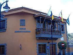
Ingenio is a town and a Spanish municipality in the eastern part of the island of Gran Canaria in the Province of Las Palmas in the Canary Islands. Its population is 29,978 (2013), and the area is 38.15 km2 (14.73 sq mi).
Map of Ingenio, Las Palmas, Spain
Ingenio is situated between the mountains and the Atlantic Ocean, 24 km (15 mi) south of the island's capital Las Palmas and 9 km (6 mi) south of Telde. The municipality includes the town Carrizal. The GC-1 motorway passes east of the town, and the Gran Canaria Airport is situated in the eastern part of the municipality. In agriculture, sugar cane is one of the dominant crops in Ingenio.
The municipality is home to the International Folklore Festival which has the participation of music groups worldwide including Mexico, Colombia, Romania, Russia and Uganda.
