
- location near Dale - location south of Blue Length 24 km Mouth Middle Island Creek | - elevation 1,058 ft (322 m) - elevation 686 ft (209 m) Basin area 83.66 km² | |
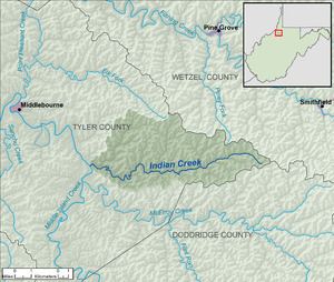 | ||
Indian Creek is a tributary of Middle Island Creek, 14.8 miles (23.8 km) long, in northern West Virginia in the United States. Via Middle Island Creek and the Ohio River, it is part of the watershed of the Mississippi River, draining an area of 32.3 square miles (84 km2) in a rural region on the unglaciated portion of the Allegheny Plateau.
Indian Creek's course is entirely in eastern Tyler County. It rises near the common boundary of Tyler, Wetzel, and Doddridge counties and flows generally westward, through the unincorporated communities of Dale, Stringtown, Braden, Booher, and Big Moses. It flows into Middle Island Creek from the east, a short distance south of the community of Blue.
References
Indian Creek (Middle Island Creek) Wikipedia(Text) CC BY-SA