
NRHP Reference # 66000757 Area 69 ha Added to NRHP 15 October 1966 | Designated NHL January 20, 1961 Phone +1 307-577-5150 | |
 | ||
Location 60 mi. SW of Casper on WYO 220, Natrona County, Wyoming, USA Address State Route 220, Alcova, WY 82620, USA Hours Open today · Open 24 hoursSaturdayOpen 24 hoursSundayOpen 24 hoursMondayOpen 24 hoursTuesdayOpen 24 hoursWednesdayOpen 24 hoursThursdayOpen 24 hoursFridayOpen 24 hours Similar Devil's Gate, South Pass, Fort Laramie National, Chimney Rock National, Fort Bridger | ||
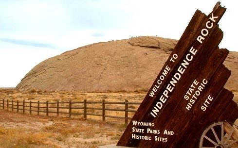
Independence Rock is a large granite rock, approximately 130 feet (40 m) high, 1,900 feet (580 m) long and 850 feet (260 m) wide, in southwestern Natrona County, Wyoming, along Wyoming Highway 220. During the middle of the 19th century, the rock was a prominent and well-known landmark on the Oregon, Mormon, and California emigrant trails. Many of these emigrants carved their names on the rock, and it was described by early missionary and explorer Father Pierre-Jean De Smet in 1840 as the Register of the Desert. The site was designated a National Historic Landmark on January 20, 1961. It is now part of Independence Rock State Historic Site, owned and operated by the state of Wyoming.
Contents
Description
The rock is a large rounded monolith of Archean granite typical of the surrounding region and is an isolated peak at the southeast end of the Granite Mountains. Its appearance is somewhat like the rounded Enchanted Rock of Texas or Uluru in Australia (formerly known as Ayers Rock), although smaller in size. It is located in the high plateau region of central Wyoming, north of the Sentinel Rocks ridge and adjacent to the Sweetwater River. It is accessible from a rest area on Wyoming Highway 220, approximately 20 miles (32 km) northeast of Muddy Gap and 60 miles (97 km) south-west of Casper.
There have been several theories regarding how the rock was carved. One explanation that comes from The History Channel states that several stonecarvers set up shop on the rock and charged a small fee to carve names. This would explain the fact that some names appear to be from the same hand and are professional looking as well.
History
The rock derives its name from the fact that it lies directly along the route of the Emigrant Trail and that emigrant wagon parties bound for Oregon or California, which usually left the Missouri River in the early spring, attempted to reach the rock by July 4 (Independence Day in the United States), in order to reach their destinations before the first mountain snowfalls. John C. Frémont camped a mile below this site on August 1, 1843, and made this entry in the journal of his 1843-'44 expedition:
"Everywhere within six or eight feet of the ground, where the surface is sufficiently smooth, and in some places sixty or eighty feet above, the rock is inscribed with the names of travelers. Many a name famous in the history of this country, and some well known to science, are to be found among those of traders and travelers..."
Fremont carved a large cross into the rock monolith, which was blasted off the rock on July 4, 1847 by some among hundreds of California and Oregon emigrants who had gathered on the site. Some Protestants considered the cross Fremont carved to be a symbol of the Pope and Catholicism. John Frémont was actually a member of the United States Episcopal Church.
On July 4, 1862, Independence Rock was the site of Wyoming's first Masonic Lodge meeting.