
Country Japan Prefecture Aichi Prefecture - Flower Chrysanthemum Population 136,442 (2010) | Region Chūbu (Tōkai) - Tree Pine Area 79.35 km² Local time Sunday 6:11 AM | |
 | ||
Time zone Japan Standard Time (UTC+9) Weather 0°C, Wind NW at 6 km/h, 62% Humidity Colleges and Universities Nagoya Bunri University, Aichi Bunkyo Women's College | ||
Trip to inazawa aichi ken
Inazawa (稲沢市, Inazawa-shi) is a city located in Aichi Prefecture, Japan.
Contents
- Trip to inazawa aichi ken
- Map of Inazawa Aichi Prefecture Japan
- Geography
- Surrounding municipalities
- History
- Railways
- Highways
- Education
- Sister city relations
- Notable people from Inazawa
- References
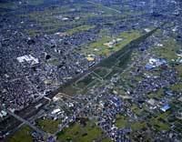
Map of Inazawa, Aichi Prefecture, Japan
As of May 2015, the city had an estimated population of 136,551 and a population density of 1,720 persons per km2. The total area was 79.35 square kilometres (30.64 sq mi).
Inazawa is the location of the Solae elevator testing tower, the highest such tower in the world.
Geography
Inazawa is located in the coastal flatlands of far western Aichi Prefecture, bordering Gifu Prefecture on the west.
Surrounding municipalities
History
Inazawa is the location of the Nara period provincial capital and provincial temple of Owari Province. The Owari Onkunitama Jinja, an important Shinto shrine located within the borders of the present city, also dates from this period. During the Edo period, Inaba and Ozawa villages formed a post town on the Minoji, a kaidō connecting Miya-juku (Atsuta on the Tōkaidō to Tarui-juku (Mino Province) on the Nakasendō. During the Meiji period, the town of Inazawa was created. The area of the town was expanded in 1907 and 1955 through the annexation of neighboring villages, and on November 1, 1958, the Inazawa was elevated to city status.
On April 1, 2005, the towns of Heiwa and Sobue (both from Nakashima District) were merged into Inazawa.