
Country United States Area code(s) 580 Elevation 144 m Population 7,007 (2013) | Time zone Central (CST) (UTC-6) FIPS code 40-36750 Zip code 74745 | |
 | ||
Weather 17°C, Wind S at 2 km/h, 88% Humidity University Kiamichi Technology Center-Idabel | ||
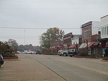
Idabel is a city in and county seat of McCurtain County, Oklahoma, United States. The population was 7,010 at the 2010 census. It is located in the southeast corner of Oklahoma, a tourist area known as Kiamichi Country.
Contents
- Map of Idabel OK 74745 USA
- History
- Geography
- Climate
- Demographics
- Economy
- Public schools
- Advanced education
- Notable people
- References
Map of Idabel, OK 74745, USA
History
Idabel was established in 1902 by the Arkansas and Choctaw Railway (later part of the St. Louis and San Francisco Railway (Frisco). The city was first named Purnell, after Isaac Purnell, a railroad official. When postal officials rejected that designation, the name was changed to Mitchell, honoring another railroad company officer. Postal officials also rejected because another post office of that name existed elsewhere in the territory. They named the post office Bokhoma (a Choctaw word meaning Red River), which opened December 15, 1902. Railroad officials then chose the name Idabel, a compound of the names of Isaac Purnell's two daughters, Ida and Bell. The post office was then renamed Idabel.
For its first four years, Idabel local government was the responsibility of the Choctaw tribe for the Indians themselves. The national government was responsible for enforcing the law among non-Choctaws. In 1906, the citizens elected their first mayor and established a mayor-council form of government. At the time of statehood, November 16, 1907, the town was designated as the county seat of McCurtain County. A census in that year reported 726 residents. By 1910, the population had grown to 1,493. In 1920, there were 3,617 residents, but the number fell to 2,581 in 1930. Growth resumed by the end of the Great Depression in the late 1930s.
Geography
Idabel is located at 33°53′47″N 94°49′45″W (33.896299, -94.829238).
According to the United States Census Bureau, the city has a total area of 15.9 square miles (41 km2), of which, 15.9 square miles (41 km2) of it is land and 0.06% is water.
Idabel lies between the Little River and the Red River, about 21 miles (34 km) west of the Oklahoma-Arkansas state line and 40 miles (64 km) east of Hugo.
Climate
The climate in this area is characterized by hot, humid summers and generally mild to cool winters. According to the Köppen Climate Classification system, Idabel has a humid subtropical climate, abbreviated "Cfa" on climate maps.
Demographics
As of the census of 2000, there were 7,658 people, 2,735 households, and 1,785 families residing in the city. The population density was 436.3 people per square mile (168.5/km²). There were 3,129 housing units at an average density of 196.4 per square mile (75.8/km²). The racial makeup of the city was 56.99% White, 24.45% African American, 10.44% Native American, 0.30% Asian, 0.01% Pacific Islander, 3.37% from other races, and 4.43% from two or more races. Hispanic or Latino of any race were 4.96% of the population.
There were 2,735 households out of which 34.4% had children under the age of 18 living with them, 39.6% were married couples living together, 21.2% had a female householder with no husband present, and 34.7% were non-families. 31.6% of all households were made up of individuals and 12.9% had someone living alone who was 65 years of age or older. The average household size was 2.45 and the average family size was 3.08.
In the city, the population was spread out with 29.5% under the age of 18, 9.2% from 18 to 24, 26.0% from 25 to 44, 20.7% from 45 to 64, and 14.6% who were 65 years of age or older. The median age was 34 years. For every 100 females there were 85.6 males. For every 100 females age 18 and over, there were 81.0 males.
The median income for a household in the city was $20,496, and the median income for a family was $24,189. Males had a median income of $24,182 versus $16,958 for females. The per capita income for the city was $12,241. About 28.7% of families and 31.3% of the population were below the poverty line, including 42.5% of those under age 18 and 18.4% of those age 65 or over.
Economy
Initially, timber was the basis for the local economy, but this was supplanted by cotton production after the nearby forests were cleared. One cotton gin operated in Idabel in 1904, but six were in business in 1930. However, the Great Depression, depleted soil and destructive pests essentially wiped out this industry around Idabel. Landowners converted their properties to pastures and expanded beef production. Chicken farms were also established in the area and marginal agricultural land was turned into pine plantations.
Public schools
Idabel Public Schools serves the community.