
Formed November 13, 2006 Fatalities None Areas affected Guerrero Affected areas Guerrero, Mexico | Dissipated November 20, 2006 Damage None Highest winds 177 km/h | |
 | ||
Lowest pressure 965 mbar (hPa); 28.5 inHg Date 13 November 2006 – 20 November 2006 Similar Hurricane Paul, Hurricane Kristy, Hurricane Ileana, Tropical Storm Emilia, Hurricane John | ||
Hurricane Sergio was the third strongest Pacific hurricane in the month of November on record. The nineteenth named storm and eleventh hurricane of the 2006 Pacific hurricane season, Sergio developed from a tropical wave on November 13 about 460 miles (740 km) south of Manzanillo, Mexico, and steadily intensified as it tracked southeastward. It reached peak winds of 110 mph (175 km/h) on November 15, and subsequently began to weaken due to increased wind shear as it turned to the north. Sergio later turned to the west, remaining well off the coast of Mexico, and dissipated on November 20 about 320 miles (515 km) west-northwest of it originally formed.
Contents
Sergio produced light rainfall along the coast of Mexico, though its effects were minimal. The formation of Sergio marked the 2006 season as the busiest in 12 years and the first season in which more than one tropical storm formed in November. Sergio, in addition to being the strongest hurricane after November 1, was also the longest-lived Pacific tropical cyclone in November, lasting a total of seven days.
Meteorological history
A tropical wave crossed Central America and entered the eastern Pacific Ocean on November 7. An area of convection along the wave tracked westward to the south of Central America and Mexico, and became more concentrated on November 12 while located about 400 miles (645 km) south of Acapulco. Later that day, Dvorak classification began on the disturbance, and the convection continued to organize. Early on November 13, the National Hurricane Center indicated the possibility of the system developing into a tropical depression. Thunderstorm activity briefly decreased, though late on November 13 the system acquired enough circulation and organized convection for it to be designated Tropical Depression Twenty-One-E while located about 460 miles (740 km) south of Manzanillo, Mexico. Operationally, the depression was not upgraded until eleven hours later.
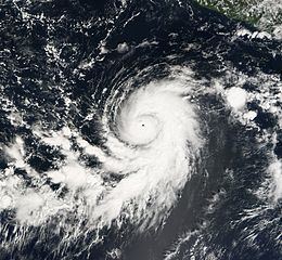
Initially, the tropical depression tracked to the northwest, and was forecast to peak as a 50 mph (80 km/h) tropical storm while continuing on a northwest motion. Located within an area of weak wind shear, deep convection increased near the center, and banding features became more pronounced. Anticyclonic flow aloft and a moist troposphere allowed the depression to intensity into Tropical Storm Sergio on November 14. Shortly after becoming a tropical storm, Sergio turned to the southeast, believed to be due to the flow associated with a mid- to upper-level trough to its northeast. It steadily intensified, and Sergio attained hurricane status on November 15 while located about 420 miles (675 km) southwest of Acapulco. With a small, distinct eye located in the center of the deep convection, Sergio rapidly intensified to attain peak winds of 110 mph (175 km/h) about 6 hours after becoming a hurricane.
Upon reaching peak strength, forecasters at the National Hurricane Center predicted Hurricane Sergio to intensify further to reach winds of 120 mph (195 km/h). Shortly after peaking, the hurricane turned to the north and gradually weakened as wind shear from an upper-level trough to its northwest increased. By early on November 17, the low-cloud circulation became partially exposed on the west side of the deep convection, and it is estimated that Sergio weakened to a tropical storm later that day. A ridge to its north and northeast turned the storm to the northwest and later to the west as Sergio gradually weakened. Deep convection reformed near the center on November 18, resulting in a slight increase in winds, though vertical shear quickly weakened it again. Later that day, the storm made its closest approach to land, about 225 miles (360 km) southwest of Michoacán. Early on November 20 it degenerated into a tropical depression, and later that day Sergio dissipated about 360 miles (580 km) southwest of Manzanillo, Mexico, or about 320 miles (515 km) west-northwest of where it originally formed. The remnants of Sergio continued westward for about a day before the minimal amount of convection diminished.
Impact and records
No tropical cyclone warnings or watches were issued in relation to Sergio. Several storm advisories indicated a slight threat to coastal regions of Mexico; the National Hurricane Center assessed a 29% probability of tropical storm-force winds affecting Barra de Navidad in Jalisco. From November 16 and 17, the outer rainbands of the hurricane dropped light precipitation along the Mexican coastline, peaking at 1.97 inches (50 mm) at Tierra Colorada in Guerrero.
Sergio contributed to November 2006 being the most active November since Pacific hurricane records began, based on using the accumulated cyclone energy index. This record later became tied with another season nine years later. After Rosa formed a few days before Sergio, November 2006 became the first since 1961 to have more than one storm in the month. The hurricane is currently the third strongest in the month, as well as the longest-lasting.