
Formed October 15, 1986 Fatalities None reported | Dissipated October 22, 1986 Highest winds 233 km/h | |
 | ||
Date 15 October 1986 – 22 October 1986 Similar Hurricane Estelle, Hurricane Paine, Hurricane Newton | ||
Hurricane Roslyn was the strongest hurricane in the 1986 Pacific hurricane season. The 17th and final named storm of the season, Roslyn developed on October 15 to the south of Mexico. Its movement was initially guided by a ridge to its north, and it became a tropical storm on October 16 and a hurricane a day later. The hurricane reached peak winds of 145 mph (233 km/h) on October 19 before weakening and turning to the northeast. Roslyn ultimately moved ashore near Mazatlán, Sinaloa as a minimal hurricane, where it caused minimal damage due to the light population affected. It rapidly dissipated, although the remnants brought precipitation to Texas and other portions of the central and southern United States. There were no fatalities, and reported damage was minor.
Contents
Meteorological history
The final named storm of the season originated from a tropical disturbance that crossed Nicaragua into the eastern Pacific Ocean. With warm waters and increasing cyclonic organization, it developed into Tropical Depression Twenty-Four on October 15 offshore Guatemala. The system moved quickly west-northwestward under the influence of a ridge over Mexico. Quickly intensifying, the depression attained tropical storm status early on October 16; it was given the name Roslyn by the Eastern Pacific Hurricane Center. An eye became visible on satellite imagery, and by October 17 the storm reached hurricane status, while located about 400 miles (640 km) south of Acapulco, Guerrero.
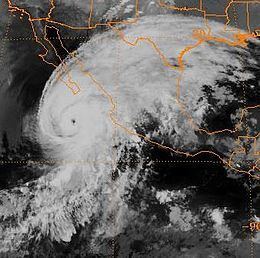
As water temperatures remained very warm along its path, the hurricane was able to intensify quickly. Roslyn reached peak winds of 145 mph (230 km/h) 48 hours after attaining hurricane status, while located about 550 miles (890 km) southwest of Manzanillo, Colima; that made it the strongest hurricane of the season. Roslyn maintained peak intensity for about 18 hours, during which it turned more to the northwest in response to a powerful advancing cold front. On October 20, the hurricane curved northeastward as steady weakening ensued. After bypassing southeast of the Baja California Peninsula, Hurricane Roslyn moved ashore on October 22 at Mazatlán, Sinaloa with winds of 75 mph (120 km/h). The low-level center rapidly dissipated, although the upper-level circulation continued northeastward along the advancing cold front. A frontal low developed in the western Gulf of Mexico, which moved over southeastern Texas and later through the Mississippi Valley. The original upper-level circulation maintained its northeast movement, bringing rainfall to the southeastern United States.
Preparations and impact
Prior to the hurricane's landfall in Mexico, officials in Mazatlán executed the evacuation of over 2,000 people in vulnerable coastal areas; such preparations prevented any deaths or injuries. Additionally, the owners of fishing vessels were advised to secure their properties by moving them to a safer area. As a result, only one yacht was sunk during the hurricane, and no major damage was reported by the fishing industry. Prior to moving ashore, Roslyn dropped light rainfall in extreme southern Baja California Sur. On the mainland, precipitation extended to the southeast and northwest of where the hurricane moved ashore; the peak total was 13.11 inches (33.30 cm) to the southeast of Mazatlán. The brunt of the storm missed Mazatlán, instead affecting a sparsely-populated area. The highest reported winds from a land station were 44 mph (71 km/h), with gusts to 53 mph (85 km/h). Roslyn produced some flooding, but no serious damage. Impact was limited to flooded homes and factories, as well as some crop damage and beach erosion.
The remnants of Hurricane Roslyn produced heavy rainfall across the central and southern United States. In Matagorda, Texas, a total of 13.8 inches (35.05 cm) was reported, which was the highest rainfall total anywhere along Roslyn's path. The system dropped upwards of 5 inches (12.70 cm) in isolated locations of Alabama, Arkansas, Alabama, Georgia, and the Carolinas. The outskirts of the remnants of Roslyn brought rainfall to areas still recovering from significant flooding, partially caused by the earlier Hurricane Paine. Clouds from Roslyn began affecting the southern United States a day before it made its original landfall. The storm prompted flash flood watches in southeastern Texas, and the resulting rainfall flooded roadways and streams.