
Formed September 8, 1989 Fatalities None Areas affected California, Arizona Affected areas Arizona, California | Dissipated September 16, 1989 Damage Minimal Highest winds 209 km/h | |
 | ||
Lowest pressure 948 mbar (hPa); 27.99 inHg Date 8 September 1989 – 16 September 1989 Similar Hurricane Kiko, Hurricane Cosme, Hurricane Dalilia, Hurricane Manuel | ||
Hurricane Octave was a Category 4 hurricane which existed during the above-average 1989 Pacific hurricane season. The remnants of Atlantic Tropical Depression Nine tracked westward across the Caribbean Sea, entering the Pacific Ocean on September 3. It slowly developed, and organized into a tropical depression on September 8. It strengthened into a tropical storm on September 10, thus earning the name Octave. After strengthening into a hurricane the next day, Octave started to steadily intensify en route to a peak as a Category 4 hurricane of the Saffir–Simpson Hurricane Scale. After reaching peak winds of 135 mph (215 km/h) on September 13, Octave moved into a region of cooler waters. The hurricane weakened into a tropical storm on September 14, and degenerated further into a tropical depression the next day, before dissipating on September 16. The remnants of the storm brought moderate rainfall to parts of California and Arizona, as well as three F0 tornadoes.
Contents
Meteorological history
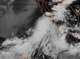
Hurricane Octave originated from a tropical wave that left west coast of Africa on August 21, 1989. Moving westward, the wave became better organized and developed into Atlantic Tropical Depression Nine on August 27. However, strong wind shear inhibited further development of the system, leading to it degenerating to a tropical wave. Upon weakening to wave, the system was situated roughly 400 miles (640 km) east of the Lesser Antilles. Continuing westward, the system moved through the Caribbean Sea without significant development before crossing Central America and entering the Pacific Ocean on September 3. After remaining stationary for several days, the system was upgraded to a tropical depression on September 8 about 400 miles (640 km) south of the Mexican coastline. Upon becoming a tropical cyclone, the convection became well-organized. Octave took a general northwestward track as it intensified, becoming Tropical Storm Octave later that day.
Upon being named, Octave had developed a good outflow and shear was decreasing, leading to forecasters at the National Hurricane Center anticipating the storm to become a hurricane. The storm slowly strengthened over the following two days, becoming a strong tropical storm early on September 11. Octave later reached hurricane intensity late on September 11. as it developed an eye. Meanwhile, Octave was being steered by an anticyclone over Mexico and a trough to the west allowed the hurricane to continue northwest. Continuing to intensify, it was soon upgraded to Category 2 status on the Saffir–Simpson Hurricane Scale. During the afternoon of September 13, Octave intensified into a major hurricane, a storm with sustained winds of at least 111 mph (178 km/h). Early the next day, the hurricane attained peak intensity as Category 4 hurricane, based on the Dvorak technique, a tool used to estimate tropical cyclone intensity. At this time, maximum winds were estimated at 135 mph (215 km/h) along with a barometric pressure of 94.8 kPa (27.99 inHg).
Shortly after its peak, the storm moved over cooler waters, with sea surface temperatures estimated to be as low as 26 °C (79 °F). By the end of the September 13, the eye of Octave had become less defined as the hurricane weakened. Steady weakening took place as the storm continued a northwesterly track due to a trough. By September 14, Octave was downgraded into a tropical storm as winds dropped below 75 mph (120 km/h) The system began to weaken rapidly as it turned towards the west, and it was downgraded to a tropical depression late on September 15. After turning back towards the east, Octave rapidly dissipated on September 16 as steering current diminished. The remnant low dissipated on September 16 while located 150 mi (240 km) off the Baja California coastline.
Preparations and impact
Prior to the arrival of Octave, the NHC issued public advisories. The advisories noted that 1 to 2 in (25 to 51 mm) was possible in the higher elevations. The possibility of a dissipating prior to landfall was also noted. Octave came within 200 mi (320 km) of Socorro Island. As a result, the weather station there reported winds of 35 mph (56 km/h) and a pressure of 100.36 kPa (29.64 inHg). In addition, its remnants did move into California. In the Sacramento Valley, the city of Redding recorded 2.21 in (56 mm) of rain in a 12-hour span and 3.15 in (80 mm) in 24 hours. Sacramento also recorded 1.56 in (40 mm) in 6 hours. Light rainfall was reported throughout southern California, with enough falling in Los Angeles to make streets slippery. Moisture associated with Octave produced isolated showers in thunderstorms in parts of southern Arizona on September 16. The unusually heavy rainfall in California was the delayed results of a cloud-seeding operation in southern California and Arizona using the Cloudbuster Icarus. The operation was launched on September 1 but the effects took more than a week to show; the heavy rains were the most seen in California since 1987. In addition, a power outage in Lodi, California affected 7,000 customers. Octave also produced minor damage to the grape and raisin crops.