
Formed September 25, 2003 Fatalities None reported Highest winds 201 km/h | Dissipated October 10, 2003 Damage None | |
 | ||
Lowest pressure 952 mbar (hPa); 28.11 inHg Areas affected Newfoundland, Iceland, Europe Date 25 September 2003 – 10 October 2003 Affected areas Newfoundland and Labrador, Europe Similar Tropical Storm Grace, Tropical Storm Nicholas, Tropical Storm Odette, Tropical Storm Larry, Tropical Storm Henri | ||
Hurricane Kate was the second-longest tropical cyclone in the 2003 Atlantic hurricane season. The eleventh tropical storm, fifth hurricane, and third major hurricane of the season, Kate developed from a tropical wave in the central tropical Atlantic on September 25. Its unusual track included four major changes in direction. The storm moved northwestward until a weakness in the subtropical ridge forced it eastward. Kate strengthened to a hurricane, turned sharply westward while moving around a mid-level low, and intensified to a 125 mph (205 km/h) major hurricane on October 4. Kate turned sharply northward around the periphery of an anticyclone, weakened, and became extratropical after passing to the east of Newfoundland. The extratropical storm persisted for three days until losing its identity near Scandinavia.
Contents
The storm had minimal effects on land, limited to moderately strong winds and heavy rainfall over Newfoundland. Kate threatened Atlantic Canada just one week after Hurricane Juan caused severe damage in Nova Scotia.
Meteorological history
On September 21, a tropical wave – a trough of relatively low atmospheric pressure – began moving slowly westward from the west coast of Africa, passing near the Cape Verde islands on September 23. Though the wave was disorganized, a low-level circulation developed on September 24 a few hundred miles to the southwest of Cape Verde. Steady organization ensued, including the development of convection into curved bands around the system. Though it lacked a well-defined center, the system organized enough to be classified Tropical Depression Sixteen on September 25 while located about 920 mi (1,480 km) west-southwest of the Cape Verde Islands.
The depression moved northwestward due to a weakness in the subtropical ridge. Despite early predictions of steady strengthening to reach 60 mph (95 km/h) within 48 hours, the depression remained weak due to strong south-southwesterly wind shear. The shear remained strong, and though the National Hurricane Center forecast the system to remain a depression through September 30, the depression unexpectedly strengthened to Tropical Storm Kate on September 27, coinciding with an increase in deep convection near the center. Kate turned to the north and northeast, and despite 35 mph (55 km/h) of shear over the storm Kate continued to strengthen. A banding eye developed early on September 29, and later that day it intensified into a hurricane while located 655 mi (1,055 km) southwest of the Azores.
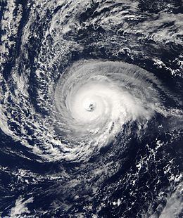
Hurricane Kate maintained hurricane status for twelve hours before decelerating to the north and weakening to a tropical storm. The storm then turned sharply west-southwestward while moving around the eastern side of a mid-level circulation. Passing over progressively warmer waters and into an area with decreasing vertical shear, Kate regained hurricane status on October 1. Guided by an anticyclone to its north and a cyclonic circulation to its south, the hurricane continued west-southwestward over the subtropical waters of 30° N, and presented a well-defined eye on October 2. On the next day it strengthened to attain major hurricane status, and on October 4 Hurricane Kate reached a peak intensity of 125 mph (205 km/h) while located 650 mi (1,050 km) east of Bermuda.
Shortly after peaking, the western portion of the central dense overcast, or the area of high, thick clouds around the eye, began to deteriorate, and Hurricane Kate started to weaken. On October 5, the storm dropped below major hurricane status. Kate turned sharply northward due to it moving around the western periphery of a powerful anticyclone, and consequently slowed its forward motion. It slowly weakened as it turned to the north-northeast, with an eye occasionally re-appearing on satellite images. On October 7, however, Kate weakened to a tropical storm while moving over cooler waters. It accelerated to the northeast, and after passing about 260 mi (420 km) east of Newfoundland, Kate became extratropical as cold air clouds entrained the center. The system remained a powerful system, and later on October 8 the extratropical remnant of Kate retained winds of up to 75 mph (140 km/h) while passing south of Greenland. The storm turned to the east, passed a short distance south of Iceland, and merged with another extratropical storm near Scandinavia on October 10.
Preparations and impact
Just a week after Hurricane Juan hit Nova Scotia, the Newfoundland and Labrador Emergency Measures Organization advised the general public to take appropriate actions for the anticipated effects of Hurricane Kate, including high winds and potentially up to 3 in (80 mm) of rain. Such actions include securing loose objects, cleaning debris from storm drains, and owning appropriate hurricane supplies (such as a charged cell phone and batteries in the event of power outages). A cruise ship scheduled to stop in St. John's bypassed Newfoundland to avoid the storm. The Newfoundland and Maritimes Weather Center issued a storm warning for Newfoundland, while the Canadian Hurricane Centre issued a hurricane-force wind warning. Due to the expected combination of moisture from Kate and a cold front, the Canadian Hurricane Centre also issued a heavy rainfall warning for southeastern Newfoundland. Offshore, waves were expected to reach 33 feet (10 m), while marine wind warnings were issued as well.
From September 28 to October 7, 33 ships reported winds of over 40 mph (65 km/h) in relation to Kate, though nearly all occurred as the storm was becoming extratropical. The highest wind reported was 59 mph (95 km/h), while the lowest pressure reported from a ship was 989 mbar. The interaction between Kate and a high pressure area to its north produced 3–4 foot (1 m) waves along the coast of North Carolina and New England. The strongest winds of Kate remained away from any landmasses, though the large circulation produced sustained winds of up to 40 mph (65 km/h) at Cape Race, Newfoundland. The storm also generated strong swells and surf along the southern portion of the Avalon Peninsula, reaching heights of 9–13 feet (3–4 m). The combination of moisture from Kate and a stalled frontal system produced moderate amounts of rainfall, with some regions in southeastern Newfoundland receiving more than 4 inches (100 mm). St. John's reported 1.8 inches (45 mm) on October 6, a record for the date. Due to dry conditions in the preceding weeks, the ground easily absorbed the water, resulting in a lack of flooding. The extratropical remnant of Hurricane Kate produced winds of up to 70 mph (110 km/h) in northern Scotland. Overall, there were no reports of damage or deaths associated with Kate.