
Formed September 10, 2004 Fatalities 0 direct, 3 missing | Dissipated September 20, 2004 Highest winds 241 km/h | |
 | ||
Lowest pressure 930 mbar (hPa); 27.46 inHg Date 10 September 2004 – 20 September 2004 Similar Hurricane Howard, Hurricane Darby, Tropical Storm Lester, Hurricane Isis, Hurricane Frank | ||
Hurricane Javier was the tenth named storm and the sixth and final hurricane of the 2004 Pacific hurricane season. Javier was also the strongest hurricane of the 2004 season, with 150 mph (240 km/h) winds and a central pressure of 930 millibars (27.46 Hg). However, because of high wind shear in the East Pacific, Javier weakened rapidly before making landfall in Baja California as a tropical depression. The remnants of the storm then continued moving northeast through the Southwestern United States. Javier caused no direct fatalities, and the damage in Mexico and the United States was minimal.
Contents
Meteorological history
The origins of Javier was from a tropical wave that moved off the coast of Africa on August 29. The disturbance crossed the Atlantic Ocean without further development due to unfavorable conditions. The tropical wave then combined with another low pressure system near the Leeward Islands and the two systems continued to move westward across the Caribbean Sea. The storm crossed Central America on September 9 where it gained more convection. On September 10, the disturbance became Tropical Depression 13-E at 1800 UTC. The next day, it strengthened into Tropical Storm Javier.
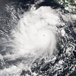
Weak wind shear allowed Javier to reach hurricane strength on September 12. Then the storm moved slowly to the west and northwest around a subtropical ridge that was centered over Mexico. Javier then underwent rapid intensification as the storm reached a peak intensity of 150 mph (240 km/h) and a central pressure of 930 millibars. These numbers qualified it as a Category 4 hurricane on the Saffir-Simpson Hurricane Scale and made it the strongest tropical cyclone of the 2004 Pacific hurricane season.
Javier then developed a concentric eyewall before weakening to a Category 3 storm. Javier maintained Category 3 status for three days before encountering cooler waters which further weakened the storm. Javier then turned northward and then northeastward before making landfall in Baja California as a tropical depression on September 19. The depression moved over Guaymas, Sonora, before losing tropical characteristics. The remnants of Javier then moved over the rest of Mexico and the Southwestern United States.
Preparations
Javier's strength was difficult to forecast. In its formation stages many of the forecast models gave out a complex suggestions of where the storm should go. One of the models forecast the storm to move west for a couple of days and then stall offshore and then turn east and hit western Guatemala. The rapid intensification was also difficult to forecast compared to average forecast errors in a ten-year period. Mexican officials began issuing tropical storm watches on September 15 as Javier paralleled the west coast of Mexico. The warnings for western mainland Mexico were then dropped as the storm did not recurve as predicted. However, more tropical storm warnings were issued for Baja California and northwestern Mexico as Javier was located 300 kilometres (186 mi) southwest of Baja California. Forecasters predicted that Javier would bring a storm surge of 1–3 feet, (0.3–1 meters)rainfall of 3-6 inches (7.6-15.2 cm), and strong rip currents. The National Hurricane Center, predicted that Javier will parallel the Baja California coastline according to their forecast models and recurve as a weak storm and dissipate over the Southwestern United States. On September 18, Mexican officials discontinued the warnings for Baja California when Javier weakened to a tropical depression before making landfall.
Impact
Winds up to tropical storm force were reported by ships at sea. On land, the storm dropped 3.14 inches (80 mm) of rain in Bacanuchi, Mexico. Javier's flooding rains damaged portions of highway 1 near Vizcaino and three fishermen were reported missing when their ship was lost during the storm. In addition, oil prices began to climb when Javier passed through the area. However, overall damage in Baja California was minimal.
In Arizona, the remnants of Javier dropped widespread, light to moderate rainfall, improving topsoil moisture and greatly affecting a prolonged drought in the Southwestern United States. Maximum rainfall in the state reached 7 in (180 mm) in Walnut Creek. In Tucson, the airport received rainfall of 0.37 inches (93 mm) while the University of Arizona reported 0.89 inches (26 mm) of rain. Lightning and rain from Javier delayed the University of Arizona Wildcats football game against the Wisconsin Badgers for 88 minutes late in the second quarter, and flooding closed several roads. Grand Canyon, Arizona received 3.30 inches (84 mm) of rain, exactly one fifth of its yearly average. The remnants of Javier also dropped 1-3 inches of rain across Utah, Colorado, New Mexico, Texas and the upper Midwest. In terms of point maxima, Javier is the rainiest tropical cyclone on record in the period 1972 — 2008 in Wyoming and North Dakota.