
Formed August 30, 2002 Fatalities None Highest winds 257 km/h | Dissipated September 6, 2002 Damage None | |
 | ||
Lowest pressure 921 mbar (hPa); 27.2 inHg Areas affected Pacific coast of Mexico, Socorro Island, California Date 30 August 2002 – 6 September 2002 Affected areas Socorro Island, California Similar Hurricane Elida, Hurricane Ava, Hurricane Gilma, Hurricane Celia, Hurricane Emilia | ||
Catergory 5 hurricane hernan 2002 hd infrared visible satellite animation
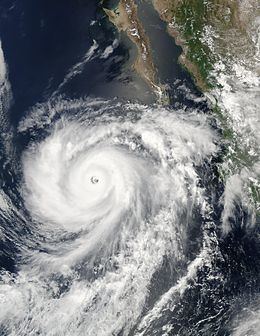
Hurricane Hernan was the second of three Category 5 hurricanes during the 2002 Pacific hurricane season. The twelfth tropical cyclone, tenth named storm and sixth hurricane of the season, Hernan originated from a tropical wave that formed in the Atlantic Ocean and crossed to the Pacific Ocean. The wave spawned a low pressure system which organized into a tropical depression on August 30, a tropical storm on August 31 and a hurricane later that day. Hernan rapidly intensified and reached peak intensity as a Category 5 storm on the Saffir-Simpson Hurricane Scale. Proceeding northwest, it maintained this strength for eight hours, but on September 2 it entered cooler waters and began to weaken. By September 6 it had degenerated into a remnant area of low pressure.
Contents
- Catergory 5 hurricane hernan 2002 hd infrared visible satellite animation
- Meteorological history
- Impact and intensity
- References
Hernan was the second most intense hurricane of the season, and it maintained Category 5 status for the second-longest time of the season, behind Hurricane Kenna. Although Hernan remained far from land, swells of 15 to 20 feet (4 to 6 meters) caused minor beach erosion along the coast of Mexico. In addition, an associated remnant plume of moisture generated light shower activity in southern California as it tracked just offshore.
Meteorological history
On August 16, a tropical wave left the coast of Africa. It traveled westward across the Atlantic Ocean, crossing over Central America and emerging in the eastern Pacific, where it merged with a pre-existing intertropical convergence zone disturbance. The system gradually developed moderate convection, and on August 30 it had developed sufficient convection to be designated Tropical Depression 10-E. The depression produced persistent strong thunderstorms, primarily in two areas of deep convection located to the northeast and west of the center of circulation. Although the center was elongated, wind shear over the system remained light and outflow was good, which led forecasters to predict modest intensification. On the afternoon of August 30, banding features became evident, and the depression was upgraded to Tropical Storm Hernan with sustained winds of 45 mph (72 km/h). Further organization occurred, and the center of circulation became encircled by convective thunderstorms. On August 31, the storm was upgraded to Hurricane Hernan as it moved northwestward about 400 miles (634 km) southwest of Acapulco.
Light wind shear and favorable ocean temperatures led to steady intensification of the storm, and satellite images indicated that an eye had developed late on August 31. Minimum pressure lowered to 987 mb (hPa), and the maximum winds increased to 100 mph, Category 2 on the Saffir-Simpson Hurricane Scale. The storm quickly reached Category 3, a major hurricane, and soon after, Category 4. As it did so, its eye became ragged, while its lateral movement to the northwest rose to 17 mph around the southern periphery of a strong deep-layer ridge over the United States. By September 1, the hurricane reached its peak intensity of 160 mph (260 km/h) and a minimum pressure of 921 mb (hPa). It had reached Category 5, the second of three such powerful storms that would do so during the season.
By September 2, the storm's convective thunderstorms warmed slightly, indicating weakening to just below Category 5. An eyewall replacement cycle took place, and two eye structures formed as gradual weakening continued. By September 2, the storm was downgraded to Category 3 just before it turned slightly to the west. The storm underwent another eyewall replacement cycle as winds decreased further. As the storm entered cooler waters, winds decreased to 100 mph (160 km/h), below major hurricane intensity. Soon Hernan was downgraded to Category 1, and the eye became cloud-filled. On September 5, Hernan was downgraded to a tropical storm as winds rapidly weakened to 45 mph (72 km/h) despite developing a new band of convection. That same day, the storm was downgraded to a tropical depression as it began to lose tropical characteristics. Strong wind shear developed, further dissipating the depression. On September 6, the system degenerated into a remnant low-pressure system which spawned a remnant plume of moisture that meandered off the coast of California, producing light showers.
Impact and intensity
Hurricane Hernan remained far from shore and caused little damage to land. It brought light wind to Socorro Island off the coast of Mexico. Rough surf caused minor impact; in the open waters near the center of Hernan, waves generated by the storm were unofficially estimated to exceed 70 feet (21 meters). However, official buoys reported swells of 57 feet (17 meters). Along the coast of Mexico, waves reached 15 to 20 feet (4 to 6 meters), causing minor beach erosion. A portion of Hernan's remnant moisture off the southern California coast produced light rainfall and slippery roads. Hernan had no known effects on shipping.
When Hernan grew from tropical storm to Category 5, it intensified at a rate of 1.73 mbar (hPa) per hour, just under the threshold for "rapid intensification". However, for a 12-hour period from August 31 to September 1, it deepened at 2.58 mbar (hPa) per hour, within the range of "explosive deepening" due to favorable conditions including light wind shear and warm water.