
Fatalities None Affected area Hawaii | Damage None | |
 | ||
Formed July 11, 2006 (2006-07-11) Dissipated July 16, 2006 (2006-07-17) Highest winds 1-minute sustained: 125 mph (205 km/h) Lowest pressure 953 mbar (hPa); 28.14 inHg Date 11 July 2006 – 16 July 2006 Similar Hurricane Sergio, Hurricane Ileana, Hurricane Paul, Hurricane Kristy, Tropical Storm Emilia | ||
Hurricane Bud was the first hurricane and second named tropical cyclone of the 2006 Pacific hurricane season. It formed as a tropical depression on July 10, to the south of the southern tip of Baja California. Shortly after, it became a tropical storm, and soon after the storm began to develop an eye. It began to intensify rapidly and was upgraded to a hurricane on July 11. Bud reached its peak intensity on July 13, becoming a Category 3 on the Saffir-Simpson Hurricane Scale at its peak. After reaching cooler waters and an unfavorable environment, the hurricane rapidly weakened and dropped to a tropical depression status on July 15. The system continued to lose its convection and eventually degenerated by the next day. As the storm remained away from land, no effects were reported as a tropical cyclone, though its remnant brought precipitation to Hawaii.
Contents
Meteorological history
On June 27, 2006, a tropical wave emerged off the west coast of Africa. It proceeded westward across the Atlantic Ocean and emerged into the eastern Pacific by July 7. The wave spawned an area of low pressure, about 630 mi (1,010 km) to the south of Manzanillo, Mexico. Interest in the system grew over the next day, and convection gradually became better organized. Early on July 11, the low was designated as a tropical depression. The storm tracked west-northwestward throughout its entire duration, under the steering currents of a mid-level subtropical ridge which extended westward from northern Mexico.
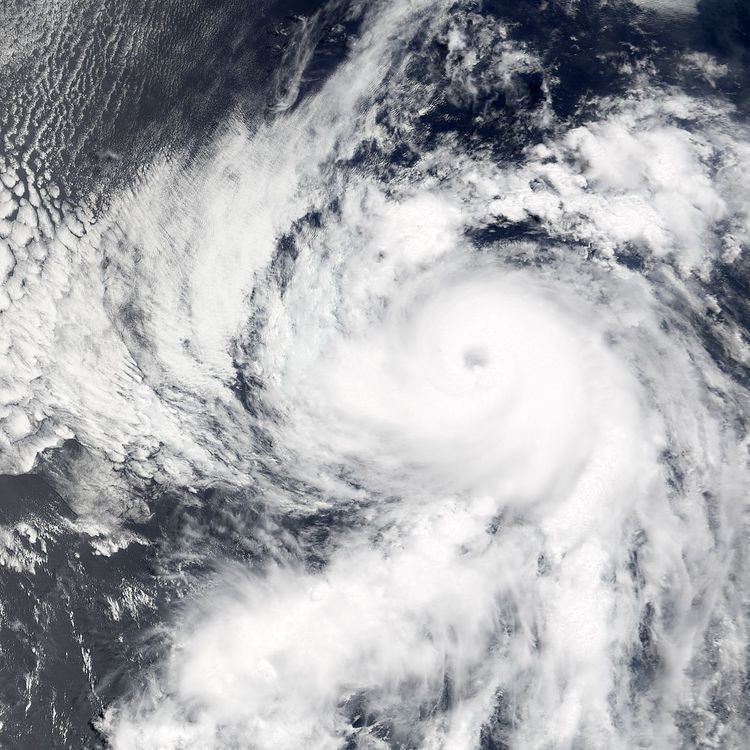
Initially, a small upper-level low pressure system to the north of the depression generated northerly wind shear and dry air, which inhibited the development of thunderstorm activity. However, after the tropical depression was designated, the low weakened, and the wind shear relented. Located over warm waters, the storm attained tropical storm status at 0600 UTC on July 11, and as such it was named Bud by the National Hurricane Center. Subsequently, the storm quickly intensified. With more favorable conditions, the storm displayed a fairly organized banding pattern, and the previously exposed center of circulation became surrounded by convection. At 0000 UTC on July 12, the storm developed an eye and was upgraded to a hurricane. The convection surrounding the center deepened, and a burst of thunderstorm activity within the southeastern eyewall obscured the eye on satellite imagery. Outflow was well established in all quadrants, though it was slightly restricted to the east, which was believed to have resulted from interaction with Tropical Storm Carlotta. Later on July 12, Bud was upgraded to a Category 2 hurricane on the Saffir-Simpson Hurricane Scale.
The storm attained major hurricane status as a Category 3 storm early on July 13. It presented a well-defined eye that was about 23 mi (37 km) in diameter, which was enveloped within by a complete ring of deep thunderstorms. A small cyclone, the area of winds contracted somewhat at around the same time. At 0600 UTC that day, the hurricane reached its peak intensity, with winds of 125 mph (205 km/h) and a minimum barometric pressure of 953 mb. Subsequently encountering cooler waters and stable air, rapid weakening began. As a result of the weakening trend, Bud became a Category 2 storm at 1800 UTC. The eye became obscured, and core convective cloud tops began to warm. Early on July 14, the storm dropped below hurricane status and lost much of its convection during the day. In addition to the cooler sea surface temperatures and an unfavorable environment, southeasterly shear contributed to the weakening. By the evening, only a patch of thunderstorm activity lingered to the north of the center. On July 15, the storm was downgraded to a tropical depression, and it degenerated into a remnant low the next day. The low fully dissipated within the low-level easterly trade winds on July 17, about 750 mi (1,210 km) east-northeast of Hawaii.
Impact
As a tropical cyclone Bud did not impact land Bud remained away from land, no effects, property damage or fatalities were reported; no ships were affected, and no tropical cyclone warnings and watches were issued. The remnants of Bud later brought light rainfall to the Hawaiian islands on July 19, two days after it dissipated.