
Basin size 406 sq mi (1,050 km) Source elevation 332 m Source Shiloh | Length 24 km Mouth Lake Erie Country United States of America | |
 | ||
Main source East of Shiloh, Ohio
1,090 ft (330 m) River mouth Lake Erie at Huron, Ohio
571 ft (174 m) Similar Lake Erie, Erie MetroParks, Black River, Old Woman Creek Na, Portage River | ||
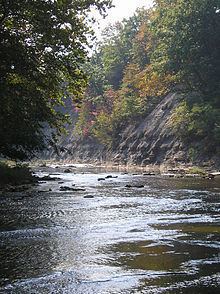
The Huron River is a 14.9-mile-long (24.0 km) waterway in the north central Ohio in the United States. The watershed drains large portions of Erie County and Huron County, the northeast corners of Seneca County and Crawford County, and northern portions of Richland County.
Contents
- Map of Huron River Huron OH USA
- TributariesEdit
- Variant namesEdit
- West BranchEdit
- East BranchEdit
- Main StemEdit
- Other informationEdit
- References
Map of Huron River, Huron, OH, USA
The mouth is on Lake Erie at the city of Huron. The main branch of the river is formed when the East and West branches merge near Milan.
The East Branch, 31.8 miles (51.2 km) long, rises west of Fitchville and flows west to North Fairfield, where it bends north and flows through Peru and Norwalk before reaching Milan.
The West Branch is 54.5 miles (87.7 km) long. It rises about 4 miles (6.4 km) south of Greenwich and four miles east of Shiloh, near the intersection of Gilger Road and Noble Road in northern Richland County's Blooming Grove Township. This is within a few miles of the headwaters of both the southwest branch of the Vermilion River (which also flows north to Lake Erie) and Shipp Creek, which is part of the Ohio River watershed via the Black Fork, Mohican, Walhonding, and Muskingum rivers. The West Branch of the Huron flows north and west from Blooming Grove Township through Huron County's Ripley Township, then back into Richland County's Cass Township and into Plymouth. It is here where the river bends north to flow across the Richland/Huron county line into Huron County's New Haven Township and into New Haven. It passes to the east of Willard, although other tributaries rise north of Willard. Still in Huron County, the West Branch continues north through Greenfield Township, Peru Township, and Ridgefield Township. The West Branch continues north into Monroeville and through the balance of Ridgefield Township. Next, the river crosses from Huron County into Erie County and then bends in an easterly direction through southern Oxford Township before reaching the confluence with the East Branch in the Milan State Wildlife Area.
TributariesEdit
Note: Willard Marsh, within the Willard Marsh State Wildlife Area, feeds into both the West Branch of the Huron River and the Honey Creek tributary of the Sandusky River. Also, there are numerous creeks, streams, and ditches that are unnamed tributaries in the Huron River basin.
Variant namesEdit
According to the Geographic Names Information System, the Huron River has also been known as:
Similarly, the West and East branches have been referred to as the West and East forks.
The Huron River had been given that name by European explorers at least by 1778, when it appears as such on a map by Hutchins. A much earlier map, by Evans in 1755, names it as the "Guahadahuri"; on that Evans map, because of the river's significant depth and navigability even at that early time, it was the only river denoted between Sandusky Bay and the Cuyahoga. Also in 1755, Pennsylvanian James Smith, who had been captured by Native-Americans and brought to this river to live among them, recorded the river's name as the "Canesadooharie". Whichever one, or both, "guahadahuri" or "canesadooharie", was the more phonetically accurate of a Native-American word, but the word's translation seems lost to obscurity. In 1760, explorer George Croghan refers to the name of this river, also phonetically from its Native-American/Chippewa tribe name, as "Notowacy Thepy"; John Heckewelder recorded it as "Naudowessie Sipi", meaning "the River ("sipi") of the Huron ("Naudowessie") tribe". Some maps of the latter-1700's also show the Huron River as "Bald Eagle Creek"; named for a large eagle's nest at its mouth at that time.
[sources: Indian Captivities (pp. 191–201) by Drake (publ.1852 by Derby and Miller); and Diary(1787-1791) of David Zeisberger, (publ.1885 by Robert Clarke and Co., Cinti.; Heckewelder's History, Manners, and Customs of the Indian Nations; publ.1876; and Diary(1804-1806) of G.S. Oppelt, Moravian Archives, Bethlehem, PA]
West BranchEdit
Here is a detailed account of which roads cross over the West Branch of the Huron River; beginning at the headwaters near Shiloh in Richland County and ending at the confluence with the east branch near Milan in Erie County.
Richland County
Blooming Grove Township
Huron County
Ripley Township
Village of Plymouth
New Haven Township
Greenfield Township
Peru Township
Ridgefield Township
Village of Monroeville
Ridgefield Township
Erie County
Oxford Township
Milan Township
East BranchEdit
Here is a detailed account of which roads cross over the East Branch of the Huron River; beginning at the headwaters near Fitchville in Huron County and ending at the confluence with the west branch near Milan in Erie County.
Huron County
Fitchville Township
Fairfield Township
Village of North Fairfield
Fairfield Township
Bronson Township
Peru Township
Ridgefield Township
US 20 / SR 18 Byp.
City of Norwalk
Norwalk Township
Erie County
Milan Township
Main StemEdit
Here is a detailed account of which roads cross over the main stem of the Huron River; beginning at the confluence of the East and West branches near Milan in Erie County and ending at Lake Erie near Huron in Erie County.
Erie County
Milan Township
Huron Township
City of Huron