
Population 4,692 (2011 census) State electorate(s) Canterbury Postal code 2193 | Postcode(s) 2193 Hurlstone Park Marrickville | |
 | ||
Location 9 km (6 mi) inner-west of Sydney CBD LGA(s) Canterbury-Bankstown Council
Inner West Council Federal divisions Division of Barton, Division of Grayndler, Division of Watson | ||
Hurlstone Park is a suburb in the Inner West of Sydney, New South Wales, Australia. Hurlstone Park is located nine kilometres south-west of the Sydney central business district and is mostly in the local government area of the Canterbury-Bankstown Council, and partly in the Inner West Council. The suburb is bounded by: the Cooks River to the south, Garnet Street to the east, New Canterbury Road to the north, Canterbury Road to the north-west, and Church Street to the west.
Contents
- Map of Hurlstone Park NSW 2193 Australia
- History
- Transport
- Commercial area
- Pubs and clubs
- Houses
- Parks and reserves
- Churches and religion
- Schools
- Population
- References
Map of Hurlstone Park NSW 2193, Australia
History
Hurlstone Park was first known as 'Wattle Hill' and then 'Fernhill'. After the Postmaster-General's Department refused to open a post office called Fernhill, a 1910 referendum chose the name 'Hurlstone', after the nearby Hurlstone College. John Kinloch founded the college in 1878, on the site of present-day Trinity Grammar School and named it after his mother's maiden name, which was Helen Hurlstone. The college moved to a new site, now known as Hurlstone Agricultural High School. The 'Park' was added at the request of the Railways Department, to avoid confusion with the New South Wales town of Hillston.
Transport
Hurlstone Park railway station is a Sydney Trains station (located 8.8 km from Central Station) on the Bankstown line. Sydney Buses provides the following services in Hurlstone Park: 444; 445 (to Balmain via Dulwich Hill, Petersham, Lilyfield, Leichhardt and Rozelle), 428 (to the city via Canterbury, Dulwich Hill, Petersham, Marrickville and Newtown) and L28 routes which run along the Canterbury Road and New Canterbury Road boundary, and the 418 (to Burwood via Ashfield, and to Bondi Junction via Dulwich Hill, Marrickville, Sydenham, St Peters, Alexandria, Mascot, Rosebery, Eastlakes, Kingsford, Randwick and Queens Park), and 406 (to Five Dock via Ashfield) routes which pass through the suburb (along Crinan Street with a bus stop directly outside the railway station).
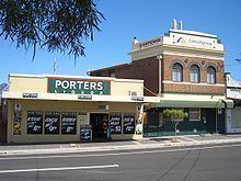
Commercial area
There is a group of shops around Hurlstone Park Station: along Crinan Street, the southern end of Duntroon Street and Floss Street. There are also commercial areas along Canterbury Road and New Canterbury Road.
The rest of the commercially used land in Hurlstone Park is made up of various shops, ranging from fast food outlets and milk bars to a couple of petrol stations. Hurlstone Park also has three childcare centres. Specific to Hurlstone Park village are the following businesses: two cafés, a seven-day supermarket, newsagent, gourmet butcher, lawyer, dry cleaner, laundry service, post office, doctor's surgery, dentist, shoe repair, bakery, real estate agent, naturopath, seven day bottle shop, convenience store, three hairdressers, an Asian grocery store and two ATM's (one CBA and one Citibank).
There is an active, local Chamber of Commerce: Canterbury-Hurlstone Park Chamber of Commerce.
Pubs and clubs
Hurlstone Park contains the following clubs and pubs:
Houses
Hurlstone Park is a predominantly residential suburb. The majority of the residential land in Hurlstone Park is single dwelling housing ie.detached houses. Only a small proportion of the residential land is multiple dwelling housing such as units or townhouses, though recent planning approvals indicate that this proportion is likely to grow.
Parks and reserves
Hurlstone Park includes the following parks and reserves:
Churches and religion
According to the 2011 census, the top responses for religious affiliation in Hurlstone Park were Catholic 32.7%, No Religion 21.6%, Eastern Orthodox 13.0%, Anglican 7.8% and Buddhism 3.9%.
The suburb contains the following religious establishments:
Schools
Only one school is located in Hurlstone Park. The Edgeware School is an alternative Department of Education facility, mainly for year 9 to 12 students who have been unsuccessful in mainstream schools. It is located in Burnett street (just off Tennent parade).
Population
At the 2011 census, there were 4,692 residents in Hurlstone Park. Almost half of people were born outside of Australia, with the top countries of birth being Greece 5.3%, Lebanon 3.1%, Italy 2.8%, England 2.5% and Philippines 2.2%. Just under half of residents spoke a language other than English at home. The most common languages spoken were Greek 10.4%, Arabic 5.9% and Italian 4.2%.