
- summer (DST) EDT (UTC-4) Zip code 12442 Local time Thursday 8:28 PM | Area 234.9 km² Area code 518 | |
 | ||
Weather -4°C, Wind W at 31 km/h, 50% Humidity Points of interest Hunter Mountain, New York Zipline Adventur, Hunter Mountain Fire Tower | ||
Hunter is a town in Greene County, New York, United States. The population was 2,732 at the 2010 census. The town contains two villages, one named Hunter and the other called Tannersville. The town is on the south border of Greene County.
Contents
- Map of Hunter NY 12442 USA
- History
- Geography
- Demographics
- Communities and locations in the Town of Hunter
- Points of interest
- References
Map of Hunter, NY 12442, USA
History
The town was formed in 1813 from the town of Windham, but was then called "Edwardsville". The name of "Hunter" was assumed in 1814. Afterwards, the town lost some territory to the town of Saugerties in 1814 and to Jewett in 1849.
The area became a popular tourism destination in the late 19th and early 20th centuries. It was served by the Ulster and Delaware Railroad, which brought tourists to resort towns throughout the Catskill Mountains.
Geography
According to the United States Census Bureau, the town has a total area of 90.7 square miles (235.0 km²), of which 90.4 square miles (234.3 km²) is land and 0.3 square miles (0.7 km², or 0.31%) is water.
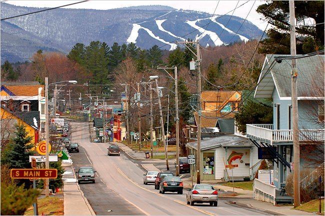
The south town line and part of the east town line are the border of Ulster County. The town is in the Catskill Mountains and the Catskill Park. Many of the Catskill High Peaks, including Hunter Mountain, the highest in the county and the second-highest in the Catskills, are in the town.
Demographics
As of the census of 2000, there were 2,721 people, 1,074 households, and 644 families residing in the town. The population density was 30.1 people per square mile (11.6/km²). There were 2,840 housing units at an average density of 31.4 per square mile (12.1/km²). The racial makeup of the town was 96.95% White, 0.59% Black or African American, 0.11% Native American, 0.15% Asian, 0.04% Pacific Islander, 0.33% from other races, and 1.84% from two or more races. Hispanic or Latino of any race were 2.09% of the population.
There were 1,074 households out of which 26.6% had children under the age of 18 living with them, 43.8% were married couples living together, 10.1% had a female householder with no husband present, and 40.0% were non-families. 34.2% of all households were made up of individuals and 12.5% had someone living alone who was 65 years of age or older. The average household size was 2.25 and the average family size was 2.88.
In the town, the population was spread out with 26.2% under the age of 18, 6.0% from 18 to 24, 23.8% from 25 to 44, 27.9% from 45 to 64, and 16.2% who were 65 years of age or older. The median age was 41 years. For every 100 females there were 102.8 males. For every 100 females age 18 and over, there were 101.8 males.
The median income for a household in the town was $33,382, and the median income for a family was $42,200. Males had a median income of $35,532 versus $22,188 for females. The per capita income for the town was $18,496. About 11.1% of families and 19.5% of the population were below the poverty line, including 24.0% of those under age 18 and 16.5% of those age 65 or over.