
Time zone MST (UTC+05:00) Max length 2.4 km | Geographic atoll North Male' Atoll Area 201 ha | |
 | ||
Similar Malé Friday Mosque, Hulhulé Island, Maafushi, Villingili, National Museum | ||
Hulhumalé or Hulhulemale (Dhivehi: ހުޅުމާލެ) is a reclaimed island located in the south of North Male Atoll, Maldives. The artificial island was reclaimed to establish a new land mass required to meet the existing and future housing, industrial and commercial development demands of the Malé region. The official settlement was inaugurated by President Maumoon Abdul Gayoom on May 12, 2004.
Contents
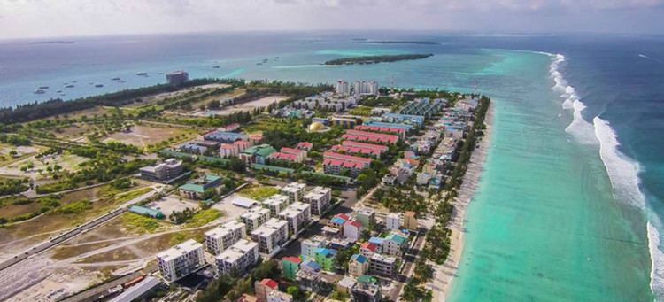
Map of Hulhumale, Maldives
The development and management of the island is undertaken by a government-owned corporation called Housing Development Corporation (formerly Hulhumalé Development Unit/Hulhumalé Development Corporation) which was incorporated on March 23, 2005.
History
Reclamation of Hulhumalé began on October 16, 1997 on the Hulhulé-Farukolhufushi lagoon 1.3 km off the north west coast of Malé. Initial reclamation (or Phase I) consisting of 45% of land mass was carried out by the Ministry of Construction and Public Works (MCPW) costing USD 11 million. The project was then continued by a Belgian Joint Venture Company, International Port Engineering and Management (IPEM) and Dredging International (DI) costing an estimated USD 21 million. All the works involving reclamation and coastal structure development covered in Phase I were completed by June 2002.
Development
A basis of development known as Phase I was formed under the first Master Plan which was completed in July 2001 by a consortium of consultants from Singapore with the contribution of many government agencies, committees and individuals. It conceptually defines the long-term land use and development strategy (including urban design proposals, transportation plans and utility infrastructure) with considerations for future infrastructure connections to the adjacent Phase II and planned airport extension areas. The Master Plan is to be periodically reviewed and adjusted to include advances in development.
Phase I of the Master Plan includes:
Stage 1A (completed)
Stage 1B (to be completed by December 2005)
Stage 1C (planned for 2006)
Stage 2 (targeted for 2016)
Stage 3 (targeted for 2020)
Hulhumalé is underutilized relative to other central atolls in the Maldives. It would take the lead of the government to improve utilization by moving government ministers, government departments and public institutions to Hulhumalé and assisting public servants with relocation costs. Pending urban development, greenery landscaping would help make the place more attractive.
On 15 January 2015 the second reclamation phase of Hulhumalé was launched, which will include the construction of a Youth Centre.