
OS grid reference SO565979 Unitary authority Dialling code 01746 Post town Shrewsbury | Civil parish Hughley Sovereign state United Kingdom | |
 | ||
Hughley (grid reference SO565979) is a village and civil parish in Shropshire, about 5 miles (8.0 km) south-west of Much Wenlock.
Contents
Map of Hughley, Shrewsbury, UK
It lies in the south Shropshire Hills, an Area of Outstanding Natural Beauty. The limestone escarpment Wenlock Edge is about 1 mile (1.6 km) south-east, and the parish lies on Wenlock Shale. Hughley Brook, which runs north-east along the western edge of the village, is the parish border with Church Preen (to the west of Hughley) and Kenley (to the north).
History
The village was known in medieval times as Legh, Leye or Lee, and the lords of the manor took its name. They are thought to be descendants of Aelfric, father of Eadric of Wenlock who was probably Eadric the Wild, an important figure at the time of the Norman Conquest. It is thought that the village acquired its distinguishing name by the end of the 13th century, after Hugh of Lee, who became lord of the manor in 1225 and died between 1271 and 1283.
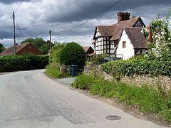
In the late 18th century most houses in Hughley were still timber-framed; later, houses were built or rebuilt with locally made brick. The resulting appearance of the village was distinct from the stone-built houses of upland settlements in the area. It is thought the parish has never had a pub.
Legend
On the parish boundary at Wenlock Edge is a rock outcrop, known as Ippikin's Rock, over a cave. There is a legend that Ippikin was a knight of the 13th century, leader of a band of robbers whose base was the cave, and were finally trapped there by falling rock.
Church of St John the Baptist
The church, a Grade I listed building, was originally a chapel in the parish of Holy Trinity, Much Wenlock, and in the late 16th century it became a parish church in its own right.
It was built in the 13th century, of limestone rubble with sandstone ashlar dressings. The nave and chancel are structurally undivided. Two lancet windows in the north of the nave are from this period. There was modification in the 14th century, when all the other windows were built. Inside, there is a late-medieval richly decorated rood screen.
There is a timber-framed belfry built about 1700. New pews were installed in 1842. The church was restored in the 1870s by Richard Norman Shaw; this included creating the trussed rafter roof and restoring the west window. There was restoration about 1900 which included reflooring the nave.