
OS grid reference SD703130 Sovereign state United Kingdom Local time Tuesday 9:22 PM Dialling code 01204 | Post town BOLTON | |
 | ||
Weather 9°C, Wind W at 14 km/h, 82% Humidity | ||
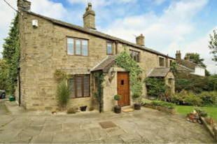
Horrocks Fold is a hamlet in Bolton, Greater Manchester, England to the south of Belmont, Lancashire. It is situated on the southern slopes of the West Pennine Moors north of Smithills Hall. Originally a farm and collection of barns and outbuildings, the site was converted to private residences in the early 1980s.
Map of Horrocks Fold, Bolton, UK
Historically a part of Lancashire, Horrocks Fold is located up an unadopted lane off Belmont Road. Several paths, tracks and nature trails lead to Horrocks Fold Wood, Scout Road, Smithills Hall and Barrow Bridge.
It should not be confused with the Horrocks Fold in nearby Edgworth, which is in Lancashire.
References
Horrocks Fold Wikipedia(Text) CC BY-SA