
Population 539 (2011 census) Mean max temp Mean min temp Elevation 4 m Postal code 4875 | Postcode(s) 4875 Mean min temp Annual rainfall Area 53 km² | |
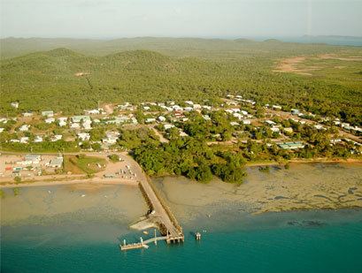 | ||
Horn Island, or Ngurupai (pronounced Nœrupai/Nurupai) in the local language, is an island of the Torres Strait Islands archipelago located in the Torres Strait, in Queensland in Northern Australia between the Australian mainland and Papua New Guinea. At the 2011 census, Horn Island had a population of 539.
Contents
Map of Horn Island, Horn QLD 4875, Australia
History
Horn Island is known as Nœrupai (colloquially Nurupai) to the Kaurareg people and was given its English name by Matthew Flinders in 1802. After the 1871 massacre on Prince of Wales Island (Muralag), remnants of the people settled here for a short while, until the government relocated the Kaurareg to Hammond Island (Kœriri), where they remained until 1922. These islands (along with the other islands in the group) are the lands of the Kaurareg, each island – or rather parts thereof – owned by different clans.
The language of the Kaurareg is Kala Lagaw Ya, in the form of Kaiwalgau Ya (called Kauraraigau Ya [colloquial variant Kauraregau Ya] in the 19th century).
Gold was mined on Horn Island in the 1890s. In the early 20th century, a town flourished as a result of the pearling industry, but declined when non-islander residents were evacuated to southern Queensland during World War II. A major Allied airbase, known as Horn Island Aerodrome, was constructed on the island and this was attacked several times by Japanese planes.
The World War II airbase on Horn Island is described in Jack Woodward's historical biographies Under It Down Under and Singing for the Unsung. Jack Woodward was a World War II RAAF wireless operator stationed on Horn Island.
Church influence: London Missionary Society up until 1915 when the Anglican Church assumed responsibility.
In 1946, some of the Kaurareg (Nœrupai) people moved back from (Kubin) on Moa Island to Horn and settled here in present-day Wasaga Village at the western end of the island. In the late 1980s, gold was mined again and Horn saw the rapid expansion of its population and building activity, as land on neighbouring Thursday Island became scarce.
Horn Island is the site of Horn Island Airport, which also serves Thursday Island. Therefore, it is a gateway for travellers to the mainland and outer islands. The present-day population consists of islanders drawn from all islands of the Torres Strait, as well as non-islanders. Residents travel daily by ferry across the Ellis Channel to Thursday Island for work and school. Shire of Torres is the local government authority, providing the island community's municipal services.
Geography
The island is 53 km2 (20 sq mi) in area.
Climate
Horn Island has a very warm tropical savanna climate with consistently hot temperatures all year round. The wet season lasts from December to April and features high humidity and frequent heavy downpours. Horn Island is occasionally affected by tropical cyclones; however it is usually too far north for them to be a significant threat. The dry season runs from May to November, and features lower humidity and little rainfall. Horn Island has never recorded a minimum temperature below 15 °C (59 °F) or a maximum temperature below 25 °C (77 °F).