
OS grid reference SO363782 Ceremonial county Shropshire Country England Dialling code 01547 | Civil parish Hopton Castle Region West Midlands Sovereign state United Kingdom UK parliament constituency Ludlow | |
 | ||
Hopton Castle is a small village and civil parish in south Shropshire, England.
Contents
Map of Hopton Castle, UK
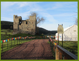
The village grew up near to the keep of Hopton Castle, which was opened as a visitor attraction in 2011. Nearby is the hamlet of Hopton Heath, with its railway station on the Heart of Wales Line. Also nearby are the villages of Bedstone, Bucknell and Clungunford.
Instead of a parish council it has a parish meeting; this is due to the very small population of the parish.
Hopton Titterhill
Within the parish, to the southwest of the village, lies Hopton Titterhill, a wooded hill which is open access land. The hill rises to 397 metres (1,302 ft) above sea level, and the summit provides a good view of the lower Clun valley.
References
Hopton Castle, Shropshire Wikipedia(Text) CC BY-SA