
Location Hesse, Germany Prominence 173 m | Elevation 618 m | |
 | ||
Coordinates 50° 6′ 31″ N, 8° 8′ 0″ E Similar Schläferskopf, Kleiner Feldberg, Hohe Kanzel, Kalte Herberge, Kellerskopf | ||
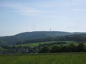
Hohe Wurzel, at 618 m, is the highest peak in the Rheingau-Taunus-Kreis mountain range and the 2nd highest mountain near Wiesbaden, Hesse, Germany. A 133 m reinforced concrete telecommunications tower is located on the peak, which supplies the Rhine Main area and other locations with digital television service as well as DAB and FM sound broadcasts.
Map of Hohe Wurzel, 65232 Taunusstein, Germany
In 1883, the Gustav Vietor Tower was built on the peak. It was last used for amateur radio purposes. The tower was demolished in March 2006.
Hohe Wurzel is located in the Rhine-Taunus Nature Park.
References
Hohe Wurzel (Taunus) Wikipedia(Text) CC BY-SA