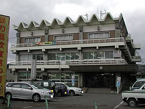
Country Japan District Higashitsugaru - Flower Camellia Population 11,222 (Feb 2015) Bird Swan | Region Tōhoku - Tree Pine Area 217.1 km² Local time Sunday 11:45 AM Prefecture Aomori Prefecture | |
 | ||
Time zone Japan Standard Time (UTC+9) Weather 3°C, Wind N at 14 km/h, 57% Humidity Points of interest Yogoshiyama Forest Park, Hiranaimachi Rekishiminzoku Museum, Okenashiyama | ||
Hiranai (平内町, Hiranai-machi) is a town located in Higashitsugaru District of northeastern Aomori Prefecture in the Tōhoku region of Japan. As of February 2015, the town had an estimated population of 11,222 and a population density of 51.7 persons per km². Its total area was 217.09 km².
Contents
- Map of Hiranai Higashitsugaru District Aomori Prefecture Japan
- Geography
- Neighbouring municipalities
- History
- Economy
- Education
- Railway
- Highway
- Notable people from Hiranai
- References
Map of Hiranai, Higashitsugaru District, Aomori Prefecture, Japan
Geography
Hiranai occupies the Natsudomari Peninsula, jutting into central Mutsu Bay. The town has a cold maritime climate characterized by cool short summers and long cold winters with heavy snow.
Neighbouring municipalities
History
The area around Hiranai was controlled by the Nambu clan of Morioka Domain during the Edo period. During the cadastral reform of 1889, Natsudomari Peninsula was divided into the three villages of Nakahiranai, Nishihiranai, and Higashihiranai. Nakahiranai became Kominato Town on October 1, 1928. On March 31, 1955, Kominato merged with Nishihiranai and Higashihiranai to form Hiranai Town.
Economy
The economy of Hiranai is heavily dependent on commercial fishing. Some of the locally caught seafood include sea urchin roe, sea cucumber, scallops, abalone and squid. Tourism also plays a role in the economy, with beaches in close proximity to the city of Aomori in summer, ski resorts in winter, and onsen all year drawing tourists.
Education
Hiranai has three elementary schools, three middle schools, one prefectural high school and one private high school.
