
- land 26.9 sq mi (70 km) - summer (DST) EDT (UTC-4) Population 12,102 (2000) | - water 0.0 sq mi (0 km), 0% Zip code 18927 Local time Saturday 2:52 PM | |
 | ||
Weather -2°C, Wind W at 27 km/h, 37% Humidity | ||
Hilltown Township is a township in Bucks County, Pennsylvania, United States. The population was 15,029 at the 2010 census. Hilltown is part of Pennridge School District.
Contents
Map of Hilltown Township, PA, USA
History
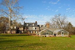
The Uneek Havana Cigar Company at Blooming Glen and Green Hills Farm are listed on the National Register of Historic Places. Green Hills Farm is also designated a National Historic Landmark.
Geography
According to the United States Census Bureau, the township has a total area of 26.9 square miles (70 km2), all of it land. It is located in the Delaware watershed and is drained by the East Branch Perkiomen Creek and Neshaminy Creek. Its villages include Blooming Glen, Fair Hill, Fricks, Griers Corner (also in Bedminster and Plumstead Townships,) Hilltown, Kulps Corner (also in Bedminster Township,) Line Lexington (also in New Britain Township and Montgomery County,) Loux Corner, Mount Pleasant, New Galena, and Unionville (also in Montgomery County.)
Neighboring municipalities
Hilltown Township surrounds the borough of Silverdale.
Demographics
As of the 2010 census, the township was 92.7% White, 2.0% Black or African American, 0.1% Native American, 3.1% Asian, 0.1% Native Hawaiian, and 1.3% were two or more races. 2.8% of the population were of Hispanic or Latino ancestry.
As of the census of 2000, there were 12,102 people, 4,275 households, and 3,390 families residing in the township. The population density was 449.7 people per square mile (173.6/km²). There were 4,370 housing units at an average density of 162.4/sq mi (62.7/km²). The racial makeup of the township was 95.94% White, 1.54% African American, 0.09% Native American, 1.08% Asian, 0.02% Pacific Islander, 0.33% from other races, and 0.99% from two or more races. Hispanic or Latino of any race were 1.46% of the population.
There were 4,275 households, out of which 37.5% had children under the age of 18 living with them, 69.1% were married couples living together, 7.0% had a female householder with no husband present, and 20.7% were non-families. 16.4% of all households were made up of individuals, and 6.8% had someone living alone who was 65 years of age or older. The average household size was 2.81 and the average family size was 3.17.
In the township the population was spread out, with 27.2% under the age of 18, 6.1% from 18 to 24, 30.6% from 25 to 44, 24.1% from 45 to 64, and 12.1% who were 65 years of age or older. The median age was 37 years. For every 100 females there were 97.5 males. For every 100 females age 18 and over, there were 94.4 males.
The median income for a household in the township was $63,178, and the median income for a family was $69,183. Males had a median income of $46,145 versus $30,566 for females. The per capita income for the township was $25,800. About 3.3% of families and 4.1% of the population were below the poverty line, including 4.8% of those under age 18 and 3.6% of those age 65 or over.