
 | ||
Points of interest Cap Tappi, Seikan Tunnel, Yomogi Hot Spring, Yogoshiyama Forest Park, Seikan Tunnel Tappi Sh | ||
Jr 40
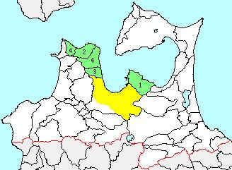
Higashitsugaru District (東津軽郡, Higashitsugaru-gun) is a rural district located in Aomori Prefecture, Japan.
Contents
Map of Higashitsugaru District, Aomori Prefecture, Japan
As of September 2013, the district had an estimated population of 24,011 and an area of 652.83 km². Much of the city of Aomori was formerly part of Higashitsugaru District.
Towns and villages
History
The area of Higashitsugaru District was formerly part of Mutsu Province. At the time of the Meiji restoration of 1868, the area consisted of one towns (Aomori) and 137 villages, formerly under the control of Hirosaki Domain and 28 villages under the control of Kuroishi Domain. Aomori Prefecture was founded on December 13, 1871, and Higashitsugaru District was carved out for former Tsugaru District on October 30, 1878.
History
With the establishment of the municipality system on April 1, 1889, Higashitsugaru District, organized into one town (Aomori) and 24 villages, was established.