
Country United States FIPS code 28-31220 Elevation 145 m Population 3,950 (2013) Area code 601 | Time zone Central (CST) (UTC-6) GNIS feature ID 0671047 Zip code 39083 Local time Saturday 8:35 AM | |
 | ||
Weather 15°C, Wind SW at 6 km/h, 90% Humidity Area 11.4 km² (11.4 km² Land / 10 ha Water) | ||
Hazlehurst is a city in and the county seat of Copiah County, Mississippi, United States, located about 30 miles (48 km) south of the state capital Jackson along Interstate 55. The population was 4,009 at the 2010 census. It is part of the Jackson Metropolitan Statistical Area. Its economy is based on agriculture, particularly tomatoes and cabbage.
Contents
- Map of Hazlehurst MS 39083 USA
- History
- Geography
- Demographics
- Education
- Rail transportation
- Notable people
- References
Map of Hazlehurst, MS 39083, USA
History
The first settlement here by European Americans became known as the town of Gallatin; two lawyers and brothers-in-law named Walters and Saunders came from Gallatin, Tennessee, in 1819 and named the village after their hometown. They built their homes on the banks of the Bayou Pierre, in the western part of Copiah County. Other settlers came with them, and in 1829 the state legislature incorporated the town. The first decades of agriculture were based on the use of slave labor of African Americans. The incorporation charter was repealed on January 18, 1862.
The construction of the New Orleans, Jackson and Great Northern Railroad began on November 3, 1865, stimulating development of Hazlehurst at the railway stop. It was named for Col. George H. Hazlehurst, an engineer for the new railroad. A city in Georgia is also named for him.
As Hazlehurst grew, Gallatin declined into a settlement at a crossroads. In April 1872, the legislature ordered the county board of supervisors to hold an election to decide whether the county seat should be moved from Gallatin to Hazlehurst. After a majority voted for the change, Gallatin's old brick courthouse was torn down and reassembled in Hazlehurst. Several years later, the old courthouse suffered a fire and was replaced by a new building. The courthouse has been destroyed and rebuilt more than 15 times during the town's history.
This city had civil rights activity during the mid-1960s. Because of violence against blacks in this area, Mississippi, the armed Deacons for Defense and Justice established centers here and in nearby Crystal Springs in 1966 and 1967. They provided physical protection for protesters working with the NAACP on a commercial boycott of white merchants to force integration of facilities and employment, and to gain jobs for African Americans following passage of civil rights legislation in 1964.
Geography
Hazlehurst is located slightly east of the center of Copiah County. U.S. Route 51 passes through the center of the city, leading north 9 miles (14 km) to Crystal Springs and south 20 miles (32 km) to Brookhaven. Interstate 55 runs west of and generally parallel to US 51, with access to Hazlehurst from exits 59 and 61. Mississippi Highway 28 crosses US 51 and I-55 in the northern part of town, leading east 14 miles (23 km) to Georgetown and west 46 miles (74 km) to Fayette.
According to the United States Census Bureau, Hazlehurst has a total area of 4.4 square miles (11.5 km2), of which 4.4 square miles (11.3 km2) is land and 0.04 square miles (0.1 km2), or 1.02%, is water.
Demographics
As of the census of 2000, there were 4,400 people, 1,594 households, and 1,131 families residing in the city. The population density was 1,004.9 people per square mile (387.9/km²). There were 1,752 housing units at an average density of 400.2 per square mile (154.4/km²). The racial makeup of the city was 29.30% White, 68.59% African American, 0.02% Native American, 0.48% Asian, 0.59% from other races, and 1.02% from two or more races. Hispanic or Latino of any race were 2.05% of the population.
There were 1,594 households out of which 34.3% had children under the age of 18 living with them, 36.5% were married couples living together, 28.0% had a female householder with no husband present, and 29.0% were non-families. 26.6% of all households were made up of individuals and 13.4% had someone living alone who was 65 years of age or older. The average household size was 2.68 and the average family size was 3.20.
In the city, the population was spread out with 28.1% under the age of 18, 10.4% from 18 to 24, 25.6% from 25 to 44, 19.9% from 45 to 64, and 16.0% who were 65 years of age or older. The median age was 35 years. For every 100 females there were 82.7 males. For every 100 females age 18 and over, there were 76.3 males.
The median income for a household in the city was $25,008, and the median income for a family was $26,081. Males had a median income of $27,066 versus $19,475 for females. The per capita income for the city was $11,839. About 24.0% of families and 26.3% of the population were below the poverty line, including 35.8% of those under age 18 and 26.7% of those age 65 or over.
Education
The city is served by the Hazlehurst City School District.
The Copiah-Jefferson Regional Library operates a branch in Hazlehurst.
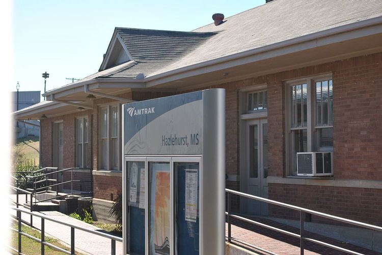
Rail transportation
Amtrak, the national passenger rail system, provides service to Hazlehurst. Amtrak Train 59, the southbound City of New Orleans, is scheduled to depart Hazlehurst at 11:55 am daily with service to Brookhaven, McComb, Hammond, and New Orleans. Amtrak Train 58, the northbound City of New Orleans, is scheduled to depart Hazlehurst at 4:17 pm daily with service to Jackson, Yazoo City, Greenwood, Memphis, Newbern-Dyersburg, Fulton, Carbondale, Centralia, Effingham, Mattoon, Champaign-Urbana, Kankakee, Homewood, and Chicago.