
Prominence 563 ft (172 m) Mountain type Tuya Mountain range Cascade Range | Age of rock 80±20 thousand years Elevation 1,683 m Parent range Cascade Range | |
 | ||
Similar | ||
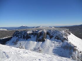
Hayrick Butte is a tuya, a type of volcano, in the Cascade Range of northern Oregon, located in the Willamette National Forest near Santiam Pass and just west of the Cascade Crest. It is adjacent to the cinder cone, Hoodoo Butte, which overlaps its western edge.
Map of Hayrick Butte, Oregon 97759, USA
A tuya is a type of subglacial volcano, formed when lava erupts underneath an overlying glacier or ice sheet and then melts through to the surface and pools, producing the flat plateau on top with near-vertical walls along the ice-contact margin as the lava cools and hardens. Hayrick Butte is one of the most perfectly formed examples of a tuya in the contiguous United States with a nearly flat triangular plateau about 0.5 miles (0.8 km) across and steep walls rising about 700 feet (210 m) above the plain below.