
- land 4.9 sq mi (12.7 km) - summer (DST) CDT (UTC-5) Population 2,271 (2012) Area code 318 | - water 0.0 sq mi (0 km), 0% Area 12.7 km² Local time Saturday 6:52 AM Number of airports 1 | |
 | ||
Weather 17°C, Wind SW at 5 km/h, 94% Humidity Parish Claiborne Parish, Louisiana | ||
Haynesville is a town in northern Claiborne Parish, Louisiana, United States, located just south of the Arkansas border. The population was 2,327 at the 2010 census.
Contents
- Map of Haynesville LA 71038 USA
- History
- Geography
- Demographics
- Government and infrastructure
- Crime
- Education
- Notable people
- Climate
- References
Map of Haynesville, LA 71038, USA
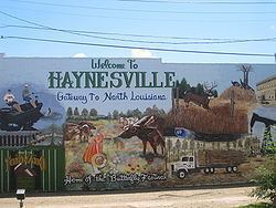
Haynesville is known as the "Gateway to North Louisiana" and the "Butterfly Capital of Louisiana". Loice Kendrick-Lacy of Haynesville has written Gardening To Attract Butterflies: The Beauty And The Beast, released by Sarah Hudson-Pierce's Ritz Publications of Shreveport. The book begins with Kendrick-Lacy as a young girl, when she was introduced to butterflies by her grandmother.
History
Haynesville was settled in 1818. The community took the name "Haynesville" in 1843 from farmer Samuel Haynes of Georgia, who established Old Haynesville some two miles south of the present site of the town. In 1898, the whole town moved north to meet the railroad, now the Louisiana and Northwest Railroad.
Modern Haynesville was built on a 1920s petroleum boom, one of the largest in Louisiana. For a time, the population reached twenty thousand. The "old boom town" was constructed in what is called Baucum Spur. It consisted of a hotel, restaurants, and saloons.
The Haynesville economy is supported still by oil as well as hunting, fishing, and timber, with considerable logging and pulpwood production in the area.
Haynesville has a variety of churches, including Baptist, United Methodist, Presbyterian, Missionary Baptist, Pentecostal, and Church of Christ.
Material on the history of Haynesville can be found at the Herbert S. Ford Memorial Museum located across from the Claiborne Parish Courthouse in Homer.
Geography
Haynesville is located at 32°57′40″N 93°8′17″W (32.961132, -93.138091).
According to the United States Census Bureau, the town has a total area of 4.8 square miles (12.5 km2), of which 4.8 square miles (12.5 km2) is land and 0.22% is water.
The most common soil is Eastwood series, which has 3 to 10 inches (76 to 254 mm) of brown very fine sandy loam over 20 inches (510 mm) of red clay. It supports a native forest vegetation of loblolly pine, shortleaf pine, southern red oak, American sweet gum and hickory.
Demographics
As of the census of 2000, there were 2,679 people, 1,087 households, and 709 families residing in the town. The population density was 545.2 people per square mile (210.7/km²). There were 1,247 housing units at an average density of 253.8 per square mile (98.1/km²). The racial makeup of the town was 49.42% White, 49.76% African American, 0.19% Native American, 0.04% Asian, 0.04% Pacific Islander, 0.07% from other races, and 0.49% from two or more races. Hispanic or Latino of any race were 0.82% of the population.
There were 1,087 households out of which 30.0% had children under the age of 18 living with them, 42.0% were married couples living together, 19.5% had a female householder with no husband present, and 34.7% were non-families. 33.5% of all households were made up of individuals and 18.8% had someone living alone who was 65 years of age or older. The average household size was 2.41 and the average family size was 3.07.
In the town, the population was spread out with 27.3% under the age of 18, 7.2% from 18 to 24, 23.7% from 25 to 44, 19.7% from 45 to 64, and 22.1% who were 65 years of age or older. The median age was 38 years. For every 100 females there were 82.7 males. For every 100 females age 18 and over, there were 75.9 males.
The median income for a household in the town was $20,406, and the median income for a family was $28,295. Males had a median income of $29,375 versus $20,278 for females. The per capita income for the town was $16,163. About 23.8% of families and 27.8% of the population were below the poverty line, including 39.9% of those under age 18 and 20.0% of those age 65 or over.
Government and infrastructure
The United States Postal Service operates the Haynesville Post Office.
Louisiana Department of Public Safety and Corrections operates the David Wade Correctional Center in an unincorporated section of Claiborne Parish near Haynesville.
Crime
In May 1999, the Haynesville Police Department discovered the skeletal remains of Shannon Capers, a 13-year-old girl who had been missing since March 8, 1997 in the woods behind the Mill Street Apartments on the north side of town. Capers had lived in the apartments and was murdered by her boyfriend, a local drug dealer named Maurice Tate, who also resided in the apartments.
Education
The Claiborne Parish School Board operates Haynesville Elementary School and Haynesville Junior-Senior High School.
The private Claiborne Academy is located in unincorporated Claiborne Parish, near Haynesville.
Notable people
Climate
The climate in this area is characterized by hot, humid summers and generally mild to cool winters. According to the Köppen Climate Classification system, Haynesville has a humid subtropical climate, abbreviated "Cfa" on climate maps.